-
Sunset at Piney Creek Wilderness

Tonight I cooked and ate my dinner down by the lake so I could watch the sunset. Copyright © 2018 Gary Allman, all rights reserved. -
Pipevine Swallowtail (Blue Swallowtail)

Dozens of these butterflies were feasting on the flowers at the mouth of Piney Creek. Copyright © 2018 Gary Allman, all rights reserved. Pipevine Swallowtail (Blue Swallowtail) Battus philenor.
 Battus philenor") Dozens of these butterflies were feasting on the flowers at the mouth of Piney Creek. Copyright © 2018 Gary Allman, all rights reserved.
Dozens of these butterflies were feasting on the flowers at the mouth of Piney Creek. Copyright © 2018 Gary Allman, all rights reserved. Battus philenor") Dozens of these butterflies were feasting on the flowers at the mouth of Piney Creek. Copyright © 2018 Gary Allman, all rights reserved.
Dozens of these butterflies were feasting on the flowers at the mouth of Piney Creek. Copyright © 2018 Gary Allman, all rights reserved. -
On the 31st Floor. Austin, Texas

Hotel Room – A bit of a change from hammock camping in the wilderness. Copyright © 2018 Gary Allman, all rights reserved. My home for the past 10 days. It’s a bit of a change from hammock camping in the wilderness.
It’s time to pack my bags and head back to Springfield. I’m going to be very pleased to get home. Our various work commitments have meant that Ginger and I have only spent two or three days under the same roof since early June. Ginger’s been off to Seatle and Canada networking, visiting friends, and attending a workshop. A couple of days after she returned I had to head out for the 79th Convention of The Episcopal Church.
And it is not over yet. Ginger is off to Colorado for a couple of weeks in August, and of course, I was away in North Carolina back in April. It’s been a mad year, travel-wise.
Speaking of hammock camping. I can’t wait to go and spend a couple of nights out in the wilderness by a lake. I don’t care how hot it is.
If you want to see what I’ve been up to in Austin here are most of the pictures I’ve taken for work.
-
Communications Director with the WEMO Youth

Communications Director with the WEMO Youth. Photo by: Liz Trader Just to prove that the diocesan Communications Director does venture out from behind his keyboard and camera once in a while. Here I am with the WEMO Youth and WEMO Jesus.
They asked for a picture with me, so I gave Liz my camera.
Taken at the 79th. General Convention of the Episcopal Church held at Austin Convention Center, Austin Texas.
-
Austin, Texas at night from the Colorado River

Austin, Texas at night from the Colorado River It’s not all business. This evening the Episcopal Communicators went out on the river to watch the bats.
-
Home from Home

Press Area. Copyright © 2018 Gary Allman, all rights reserved. It’s been a bit quiet around here, and with good reason.
We’ve had a very busy few weeks. Ginger’s been in Canada on business for 10 days, and three days after she got back I left for 10 days in Austin, Texas, flying out on July 4.
After my recent post about having a huge backlog of photos to process, I guess I shouldn’t say anything about the thousand-plus pictures I’ve come back with. Fortunately, most of those are for work and will be uploaded here as they are processed and captioned. I still ended up with quite a few personal pictures to process and post.
These pictures show the area set aside for the press and the media briefing room, which along with my hotel room became my home from home while I was away. The days were long 12-15+ hours starting at 6:00 a.m. and the nights were sometimes late — you have to relax sometime.
 Assembled media representatives at the daily briefing. There are around 150 registered media people, on and offsite covering the convention. Copyright © 2018 Gary Allman, all rights reserved.
 Press Area. There are around 150 registered media people, on and offsite covering the convention. Copyright © 2018 Gary Allman, all rights reserved.
Hotel Room – A bit of a change from hammock camping in the wilderness. Copyright © 2018 Gary Allman, all rights reserved. -
It’s all in the eyes

It’s all in the eyes – Tubby has always had problems with his eyes, it’s a birth defect. Copyright © 2018 Gary Allman, all rights reserved. Tubby has always had problems with his eyes, it’s a birth defect.
-
Oops

Bedroom Door Lock. Copyright © 2018 Gary Allman, all rights reserved. Today the new fridge-freezer was delivered.
The delivery guys called me in the morning and gave a window of 3:30 p.m. to 5 p.m. for their arrival.
So at 3:15 p.m. I was just finishing my shower (washing the chiggers off after mowing the yard) when the doorbell rang.
Delivery drivers, early? Never! Apparently, that is unless I’m in the shower. (My in-laws are quite good at arriving when I’m in the shower too. It must be something in the local water).
I was concerned that the delivery people would go on their merry way if I didn’t answer the door quickly. Which would mean I would be without a fridge for yet another week. I grabbed a towel and sprinted (okay, walked fast) to the door. I’m sure delivery drivers get to see all sorts of things, so a dripping Brit wearing a towel should be no real surprise. I let them in, showed them the old fridge and left them to get on with it.
It then occurred to me that I needed to sequester the cats, lest one of them take the opportunity of an open door to do a runner. Blue Kitteh is well renowned for this, and Sprinky is not to be trusted either. Tubby has never shown any interest in the great outdoors, but the silly half-blind and deaf creature could wander off by accident.
I found Blue Kitteh in the bedroom, unhooked the strap ‘thing’ we use to keep the door open, and shut her in. Sprinky was where she’s been every day for the last week or more — on my desk. I just had to round up Tubby, and then we’d be all secure. I found him in the ‘Sparkle Zone.’ I swept him up and carried him to the bedroom to be shut away with Blue Kitteh.
Shoot (or similar expletives).
The bedroom door was locked. I tried it several times to make sure. There certainly weren’t any keys in my pocketses. In fact, there was a distinct lack of a pocket of any sort in the towel I was wearing. Not only was I locked on the wrong side of the door that provides access to my clothes, but I’d locked Blue Kitteh in there too.
Getting to the unruly collection of keys that we keep wasn’t easy. They were beyond the kitchen, which was currently blocked by the Behemoth (our old fridge/freezer) and two guys debating whether or not they’d have to dismantle it to extract it from the house (the answer was yes).
Fortunately, the new fridge is only a baby Behemoth (isn’t that a bit of a contradiction?) because now there’s only two of us instead of five, we don’t really need a huge fridge. So at least we were spared having to dismantle that as well. Anyway, I had to wait until they were otherwise occupied, and dash past to grab a pile of keys.
Labeling all the loose keys is a job we have been putting off …
None of the first bunch I grabbed opened the bedroom door. The front door, yes. Don’t ask why I felt compelled at this time to check which locks the keys did fit. I have no idea, and I had nothing to label them with anyway.
I had to run the gauntlet of the kitchen to go back and search high and low for more keys. I ended up with over a dozen. Finally, after many false starts, I found a key that fitted, let myself in and got dressed.
Fast forward two or three hours, and I have finished removing all the awful sticky plastic wrapping stuff they mummify modern appliances with, and I’m done prizing off strips of blue tape. I even found the bits they’d carefully hidden behind the ice dispenser. After playing a few minutes of shelf Tetris I stood back to admire my work.

Baby Behemoth complete with the newly acquired ‘Toe Grill’. Copyright © 2018 Gary Allman, all rights reserved. Hold on. That’s not right. Where’s the grill that goes at the bottom of the fridge? They had lost it. I called the delivery driver, who searched the back of the truck. No, it’s not there. Ho hum.
So today (Tuesday) I went back to the store, and a very helpful shop assistant got down on the floor to prise a ‘Toe Grill’ — as the user guide calls it — off a display model. Thank you, Michael!
Addendum
Why do we have a full-blown deadlock on the bedroom door?
Children. Well, actually one particular child who, a long time ago, in a mindset far, far, away, was prone to being light-fingered. The door originally had a standard internal door lock on it. When we realized things were growing legs and walking off, we locked the door, only to discover that things still disappeared. A quick check with some sticky tape showed that our budding criminal was using a card to get the lock open — yes, that old trick really does work with some locks. So I fitted a new lock with a built-in deadbolt, rendering it childproof.
In fairness, it must be pointed out that the said child is now an absolutely wonderful adult who brings a tear to her stepfather’s eye every now and then with the things she says and does. But for Pete’s sake don’t tell her that. I’d never live it down.
Post Script
Apparently, the skills learned in her youth are still of value. A few days ago, one of our daughters managed to lock herself out of her bedroom in her apartment. The other daughter used the card trick to get them in.
-
Maybe I should stop taking pictures for a couple of years.

That’s a lot of pictures needing attention That way I might be able to clear the backlog.
-
I think I know what killed the fridge-freezer
It was the cats wot did it guv.
Today I moved the fridge-freezer out ready to be taken away tomorrow when (hopefully), the new fridge-freezer arrives.

The behemoth stands menacing anyone daring to enter the kitchen. Copyright © 2018 Gary Allman, all rights reserved. In the process, I think I discovered what killed it. I suspect it was a long lingering death caused by the buildup of cat fur.
Pride before a fall & I love it when a plan (albeit Plan B) comes together.
Around ten years ago I replaced the water line to the fridge. For some unknown reason, I didn’t fit an isolation valve (I do know better, honest!). Which left me with the dilemma of how to shift the fridge without shutting off the water main. Removing the front panel I found the water line and decided to try clamping it off with a pair of mole grips (I cannot remember what Americans call them). That worked great until I started moving the beast out, and I discovered that I’d just been very clever and cut one of the internal water lines, and not disconnected the supply. D’oh! As my hero, Homer would have said.
Looking closely at the real connection, and prying off a bit of the back cover, I realized that the supply goes to an electric shut off, which only turns on when there is a demand for water. Problem solved, I just ripped out the solenoid and cut the internal lines (again).

Plan B. That’s right, I ripped some of the guts out of it and the water is staying where it belongs — in the pipe. Copyright © 2018 Gary Allman, all rights reserved. Of course, I will have to shut the water off to hook up the new fridge-freezer, but that’ll only be for a few minutes (Fingers crossed!) and not the several hours I will probably have to wait for the new one to arrive. Of course, I may be able to get away with kinking the pipe up to stem the flow. But that’ll depend on where the hook-up is on the new fridge.
I guess it makes a change from backpacking and hiking.
-
Google Voice #Fail

This was the result of Ginger calling me via Google Voice last night.
It’s hard to figure out what happened to allow Google Voice to record itself or the phone service provider (I have no idea which it is). It’s a good transcript though. 🙂
-
Desk-buddy

Sprinky – My desk-buddy Sprinky’s been living on my desk for a week now.
Yesterday I thought Sprinky had finally grown tired of laying on my desk, but no, here she stays, pretty much 24 x 7, She only gets down for bathroom breaks and when I give her her meds — she’s on 150 ml of subcutaneous fluids every day, plus some other stuff she hates, and we argue over every morning and every night.
Putting a drip into a cat was not one of my life goals, but then again neither was giving a cat an inhaler twice a day (that would be Tubby). There’s a couple of photo opportunities I’ll have to set up. I admit I am a very reluctant James Herriot with no bedside manner, so it’s quite surprising when Sprink sits on my lap purring all the time she’s on the drip. I’m even more surprised when she stays on my lap after we finish.

 My desk-buddy appears unimpressed by the arrival of my new work laptop.
 I have some explaining to do.
Squint 
I’m Watching You. -
Will it ever end?
D’oh! In a repeat of the dishwasher dying right after I spent money on a new hammock …
The freezer died tonight, less than a week after we laid down the cash on our new furniture.
-
This Wasn’t Part Of The Plan


When I cleared my office and changed the couch I did not anticipate the increased attention my office would get from the feline members of the family.
This morning Sprinky upped the ante by discovering a way up onto my desk. She has spent the best part of the last
foureightfourteen hours sprawled under my monitor, despite my best attempts to dissuade her by listening to Spotify at high volume.Her presence would be fine if I didn’t have to keep moving my stuff to stop her from accidentally pushing things off the desk. Not to mention treading on the scanner on-off button, and sitting/walking on the touch-sensitive Wacom Tablet (I’ve since turned the touchpad mode off). Sitting on the scanner looking out of the window also appears to be another new popular pastime.

Office Couch Tri-Puss I’m going to have to get some covers for the couch as they appear unable to stick to the cat-friendly — and Gary stress relieving — camo throw (FYI the throw is a beach towel).


-
IKEA Tetris

IKEA Tetris. Copyright © 2018 Gary Allman, all rights reserved. We are childless!
The last kid flew the coop a couple of weeks ago, and ever since we’ve been busy making the house more ‘adult-friendly’. Doing so apparently works like a stack of falling dominoes, with one thing leading to another. Ginger installed a new floor into what was to become her office and decreed that the couch in my office was to return whence it came, to the ‘Sparkle Zone’ — her old office. Which left us needing a couch for Ginger’s new office, and a replacement couch for my office. I wanted a sofa bed, as we’ve been slowly removing all the sleeping options for guests by converting three of the bedrooms into studio/office spaces.
A trip to IKEA was called for. Which wouldn’t be a problem if the nearest IKEA wasn’t over 160 miles away in Kansas City.
Midday Monday, we were checking out the items we’d selected online. Selecting my IKEA goodies took me a long time — because, choices, choices. Then we had to work out how to fit everything into the van. It took a couple of attempts trying different options before we found one that squeezed everything in.
Once home (four hours later because trying to get out of Kansas City at five p.m. isn’t such a good idea) Ginger quickly assembled her sofa. I left my more challenging sofa bed to the next day — a good decision as it took a couple of hours for me to put it together and assembling the beast was the easy bit. Before I could do that I had the much harder job of emptying a couple of bookcases to make space for the new couch, and then work out where to put all the newly homeless stuff.
You may wonder why there’s no picture of Ginger’s new office. Well, while we were standing in the IKEA ‘warehouse’ measuring boxes and trying to work out if we could fit both sofas in the van, we somehow forgot to add the covers to the (huge) pile of goodies we were purchasing. A cover has been ordered online but it has failed to arrive. It must be said that IKEA’s online ordering and fulfillment system totally sucks. The cover was supposed to be delivered in two days but hadn’t been despatched on the day it was supposed to arrive. Not good.
 Result … Copyright © 2018 Gary Allman, all rights reserved.
 Sprinky Approves. Copyright © 2018 Gary Allman, all rights reserved.
The ammo box? Mao (aka Blue Kitty), is 16 now and having trouble walking and climbing, so it’s her step up onto the sofa. Plus, with all the re-arranging I’ve got nowhere else to keep this box. Not that Mao was first to check the sofa out, Sprinky — as can be seen in the picture — was the first to give it a try.
-
I Shouldn’t Laugh, But…
Painted in big letters on the back fence:
“VIDEO! DOG BITES!”
Large sign on the side of the same house:
“STOLEN DOG. $500 REWARD…”
You cannot make these things up.
-
Another Trip To Hercules Glades

All Mod-Cons including a Flintstone-esque table at the campsite above The Falls on Long Creek. . Copyright © 2018 Gary Allman, all rights reserved. When I found out my new tarp and under quilt were going to be arriving on Monday (May 21), I couldn’t resist trying to work out ways to get out and field test them. The long-range forecast for the beginning of the week looked promising. There was also a good chance of thunderstorms according to the predictions, so I decided now was going to be a good time to get the wet weather gear (a Sea to Summit Nylon Tarp Poncho) I’d been promising myself for several months. I also ordered an inexpensive camera clamp for my mini tripod.
Checking online, both could be with me Monday, so I just had to work out how to get myself out with my new gear.
The Plan
First off, to be able to spend a couple of days hiking, I needed to work all weekend. Unfortunately, that was not as successful as I hoped, which means I’ll also be working the following long weekend too (sigh).
Ginger was very busy (she has a new ebook on the way and is obviously much more conscientious than I am) so it will be another solo hike. I didn’t fancy fighting with a massive tangle of snakey undergrowth, so Piney Creek was not an option. I wanted to get a few more miles under my belt on this trip, so I decided to stick with Hercules Glades, starting at Coy Bald, heading north to the Pilots, and then taking the Tower Trail East, before heading south down the Middle Trail to the Falls. I’d spend the night nearby and hike back via the Coy Bald Trail. Ten miles and a few reasonable climbs. The only problems I could think of were weather-based. A sudden storm (and we’ve been having a lot of them) could make the ford on the approach to the Coy Bald Trailhead impassable, and if Long Creek was running high I might have problems crossing it. So my backup plan was to either go in via the Blair Ridge Trailhead or (more likely) the further away Tower Trailhead. From either, I should still be able to fit in a nice 10-mile hike.
I must admit I felt guilty about bunking off mid-week (as it were), but I’m 80 hours in credit with my part-time gig, and while I have a couple of other urgent projects — not to mention the ever stagnating (whilst growing) ‘honey-do’ list — I convinced myself that I would work a lot better with some time out in the wilderness, and it’d stop thoughts of gear testing from distracting me from my work.
The only thing that didn’t arrive on Monday was the tripod camera clamp. It was showing as delivered on the USPS tracking system, but it hadn’t been delivered. We have a long and tedious history of our mail being misdelivered, so I wasn’t that surprised. Annoyed, but not surprised.
Day One

Arca Compatible Clamp Mounted on a Ultra-Pod mini Tripod. Copyright © 2018 Gary Allman, all rights reserved. My pack weighed in at 20lbs with food, but sans water. I need to check out some of the extras I’m carrying and cut it down again – I ought to be able to get it down to 18lbs. The weight of the Poncho shown on Amazon is an annoyingly inaccurate 3.52oz. It’s 14.6oz! which is still a lot less than my other waterproofs (27.5oz), but I was hoping it was going to be very lightweight.
Shortly after 9:00 a.m. I was sitting in the van mentally checking off what I’d packed prior to leaving. A pickup pulled into the drive, and the driver emerged clutching a padded envelope. He told me it had been delivered to his house the previous afternoon. How auspicious! Great timing, my tripod camera clamp had arrived. I was most grateful and took a couple of minutes to open the package and check it out before setting out.
An hour or so later I was crossing the ford on Cross Timbers road. The creek was running fast but not deep. Good news, I was not going to have any problems with creek crossings unless there was some heavy rain and flash floods.
There were a couple of vehicles at the Trailhead, but the occupants had obviously not signed in, so I had no idea where they might be in the wilderness, or how long they were going to be there. By 10:30 a.m. I had signed in, and was off down the trail. One problem with being the first person along the trail is having to deal with all the spider webs spread across the trail to capture unwary hikers. The good news is, that it also means that there’s no one ahead of you on the trail. Or does it?
 Trail Choices – Down the hill on the Long Creek Trail to the left, and the Coy Bald Trail on the right. Copyright © 2018 Gary Allman, all rights reserved.
 You know you are the first person down the trail when … you keep on walking into spider webs. Copyright © 2018 Gary Allman, all rights reserved.
Getting near Long Creek I could hear voices, and there were several people and a couple (or more, I didn’t look too closely) tents at the spot at the bottom of the hill, to the left of the trail. That explained the vehicles at the Trailhead. I said my “Good morning … ” and kept going. I dropped off the trail to go visit the bluffs that are by Long Creek just here, and I was rather put out by seeing dozens of small (and large) cairns littering — and I use the word advisedly — the place. They made it impossible to get some of the pictures I wanted, and I had to frame some pictures awkwardly to keep the darned things out of the frame.
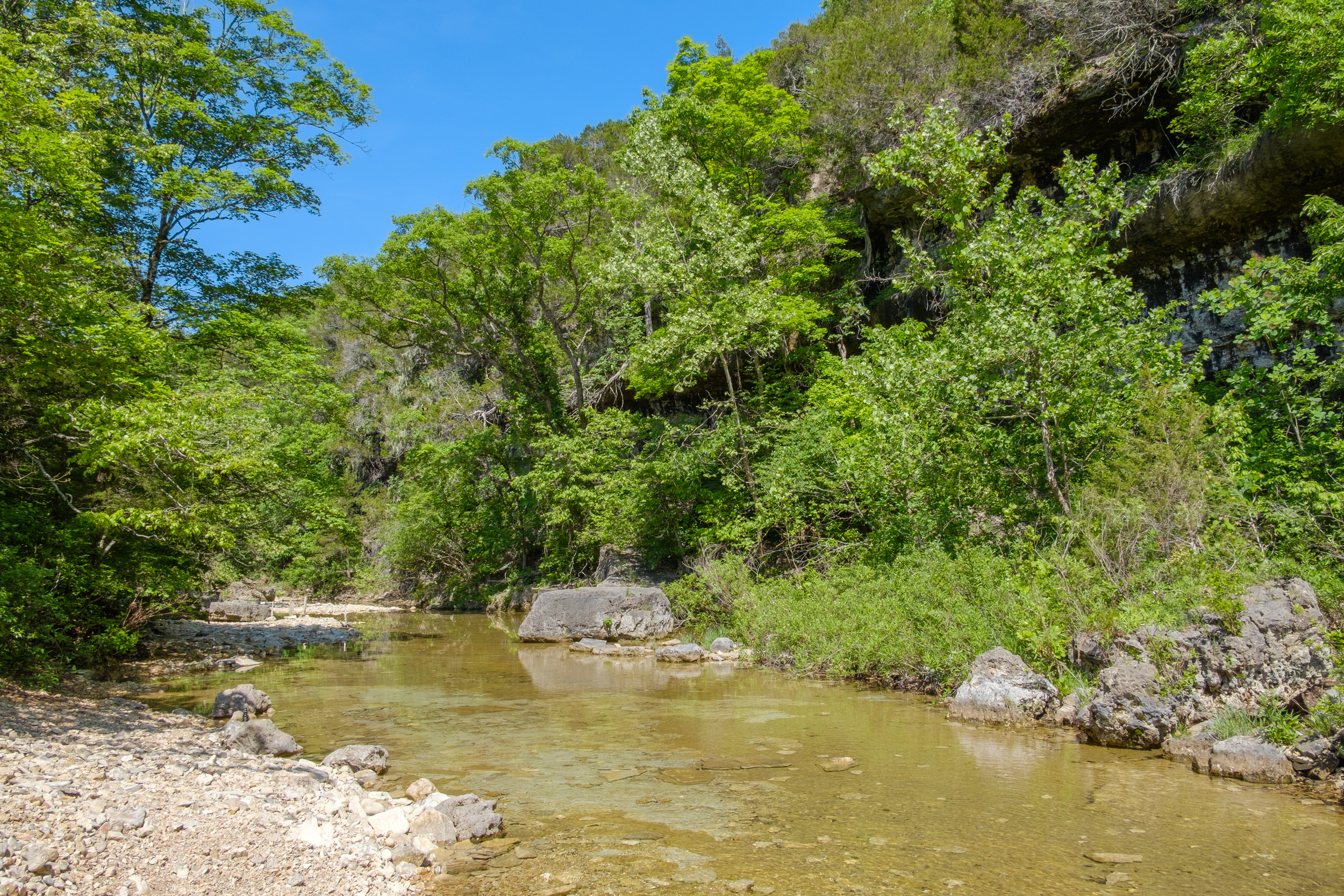
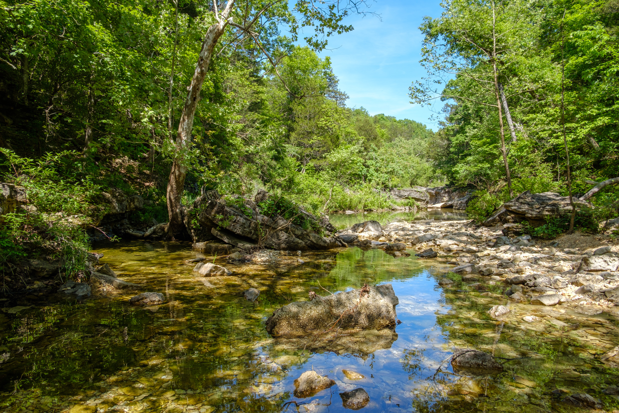
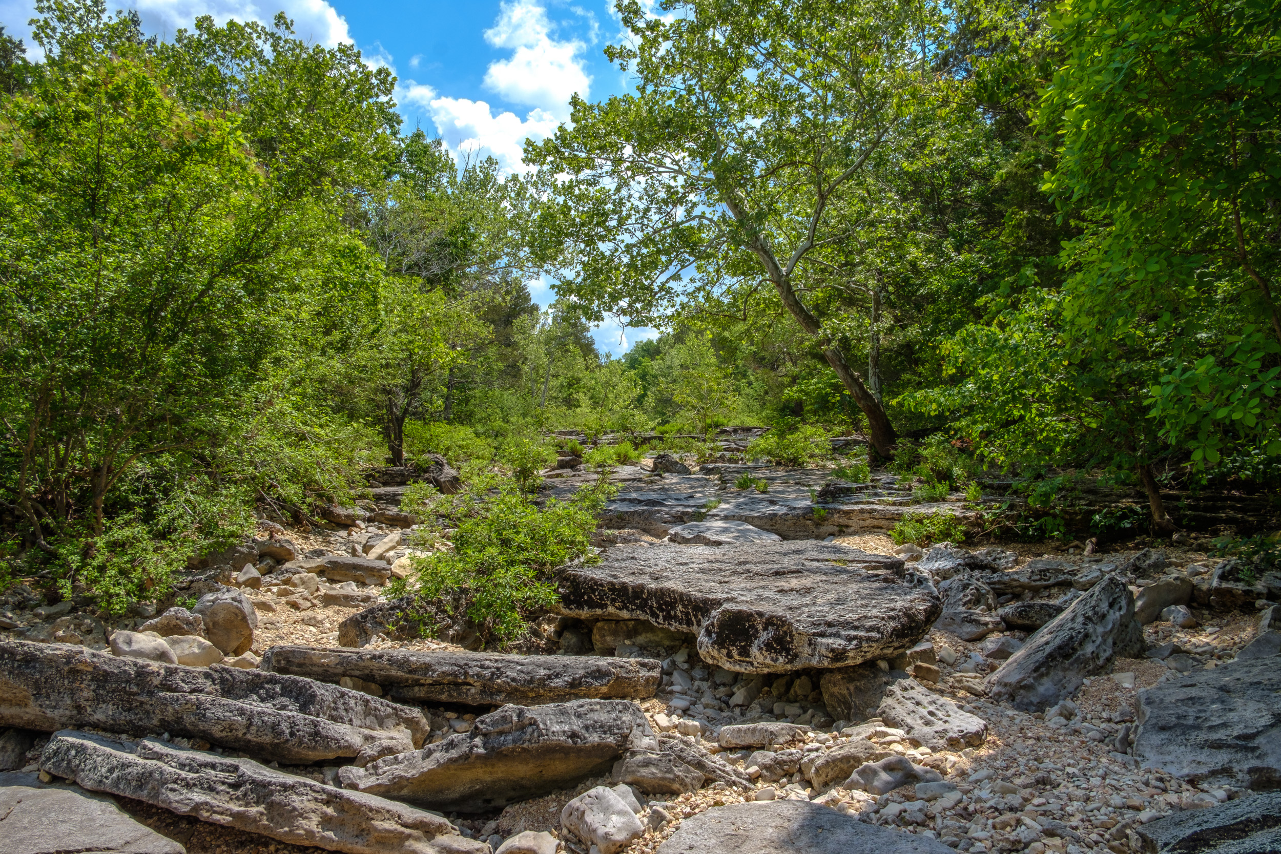
Long Creek Bluffs. Copyright © 2018 Gary Allman, all rights reserved. 
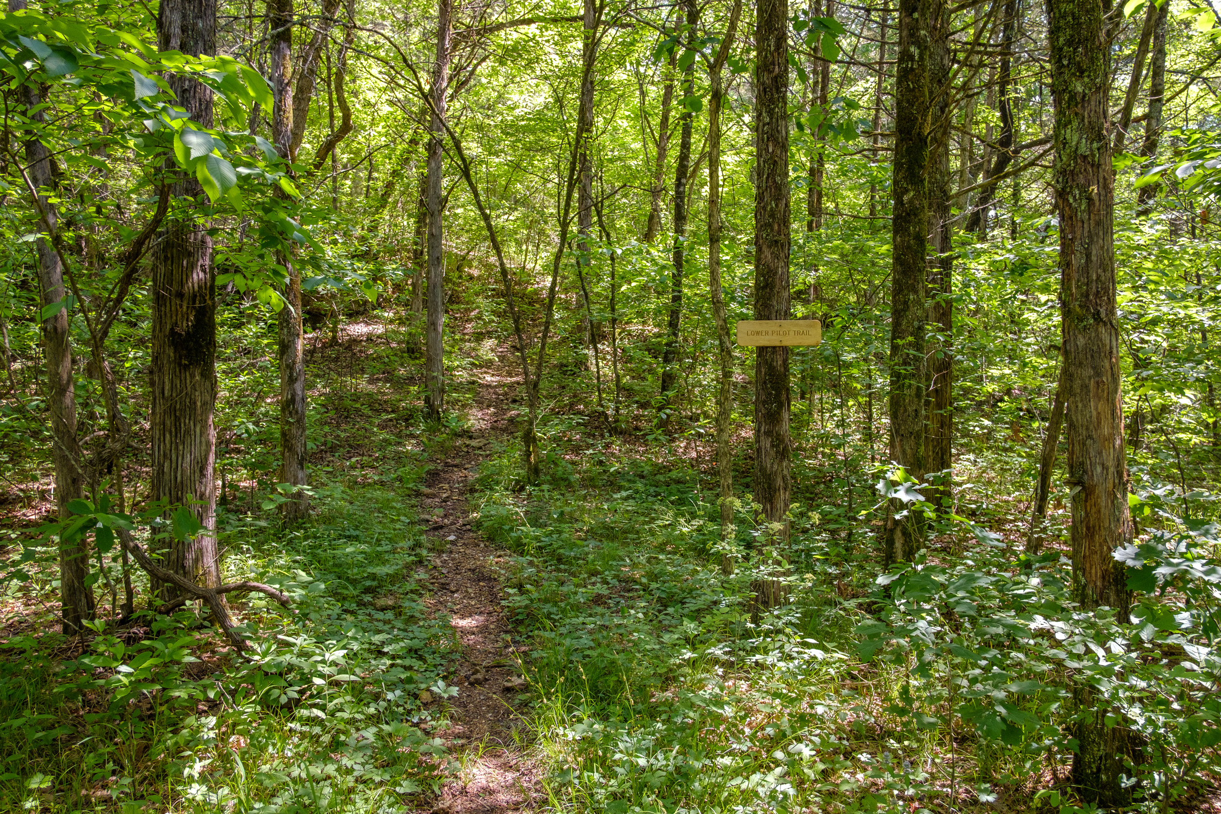
Looking East Towards Where The Trail Crosses Long Creek. Copyright © 2018 Gary Allman, all rights reserved. I have no problem with a bit of fun, but these cairns are popping up all over the wildernesses like a plague of mushrooms on steroids. It used to be that they only marked trail branches or points of interest, now they just appear at random. After having a grump and taking my pictures I high-tailed it across Long Creek and up that bloody hill that marks the southern end of the Lower Pilot Trail (and yes I was carrying water, though only two liters — 4.8lbs).

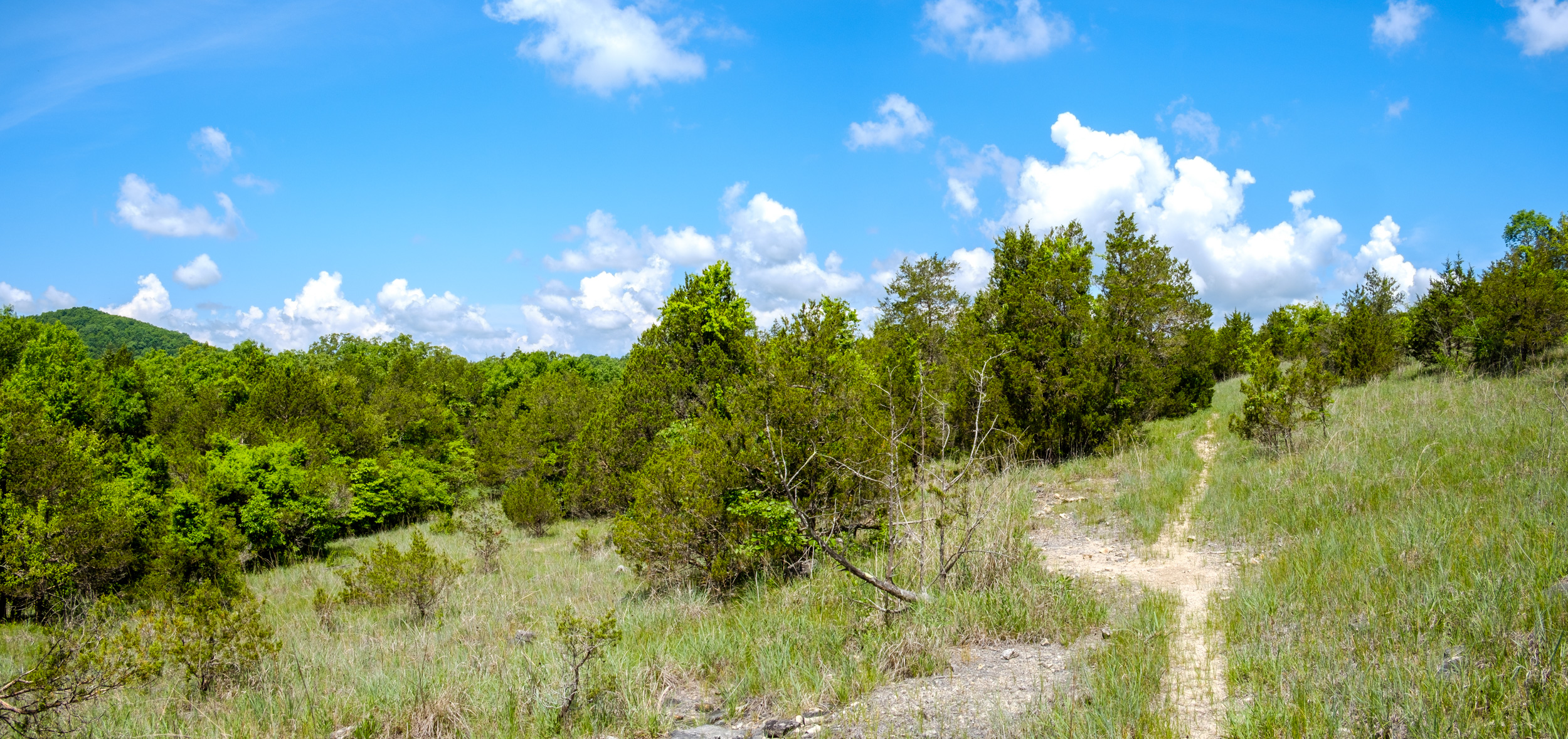
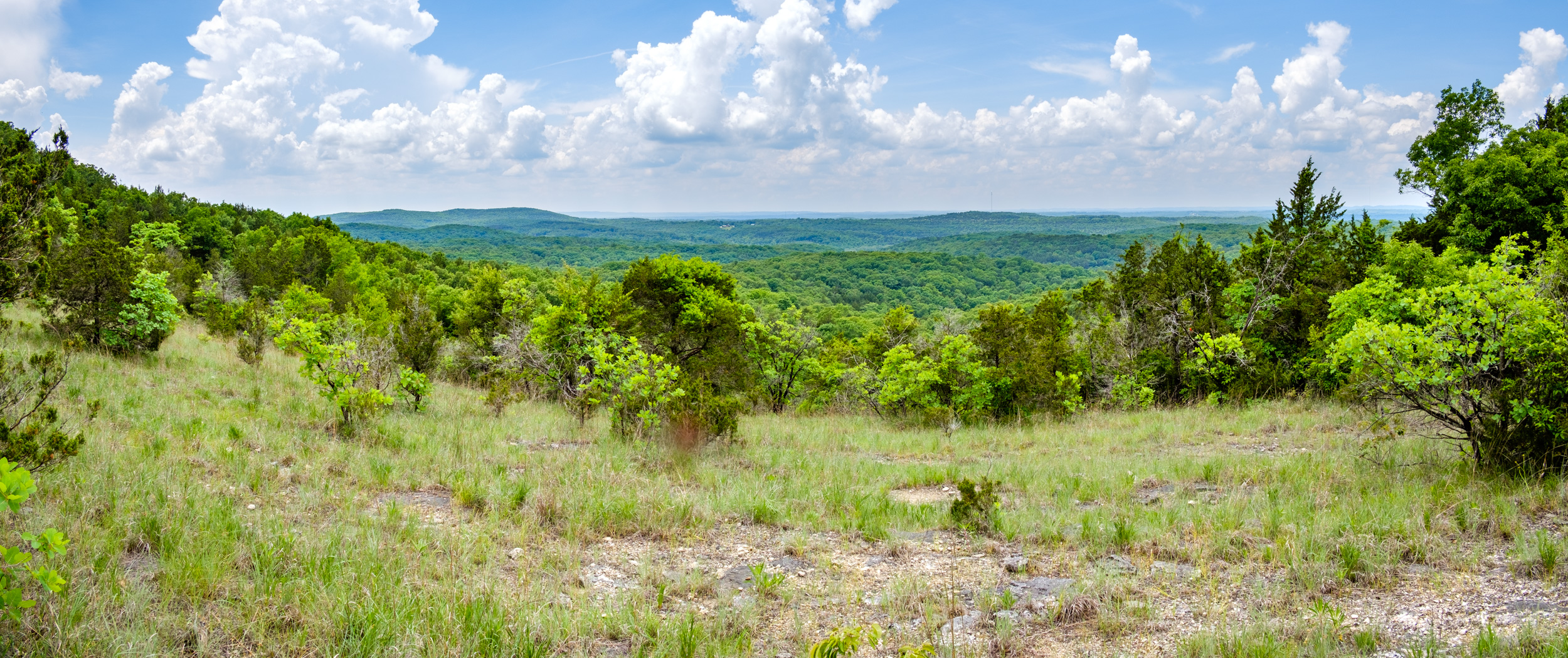
Southern End of the Lower Pilot Trail. Copyright © 2018 Gary Allman, all rights reserved. I must be getting better at this hiking thing, as I only stopped once to catch my breath, and it seemed like next to no time before I was emerging from the ridge onto the glades. Out in the sunshine it was hot. 86°F hot. I was thinking that some of those showers that were predicted might be quite welcome.

Coy Bald on the Left, Pilots on the Right. And here I am, stuck in the middle on the Lower Pilot Trail. Copyright © 2018 Gary Allman, all rights reserved. 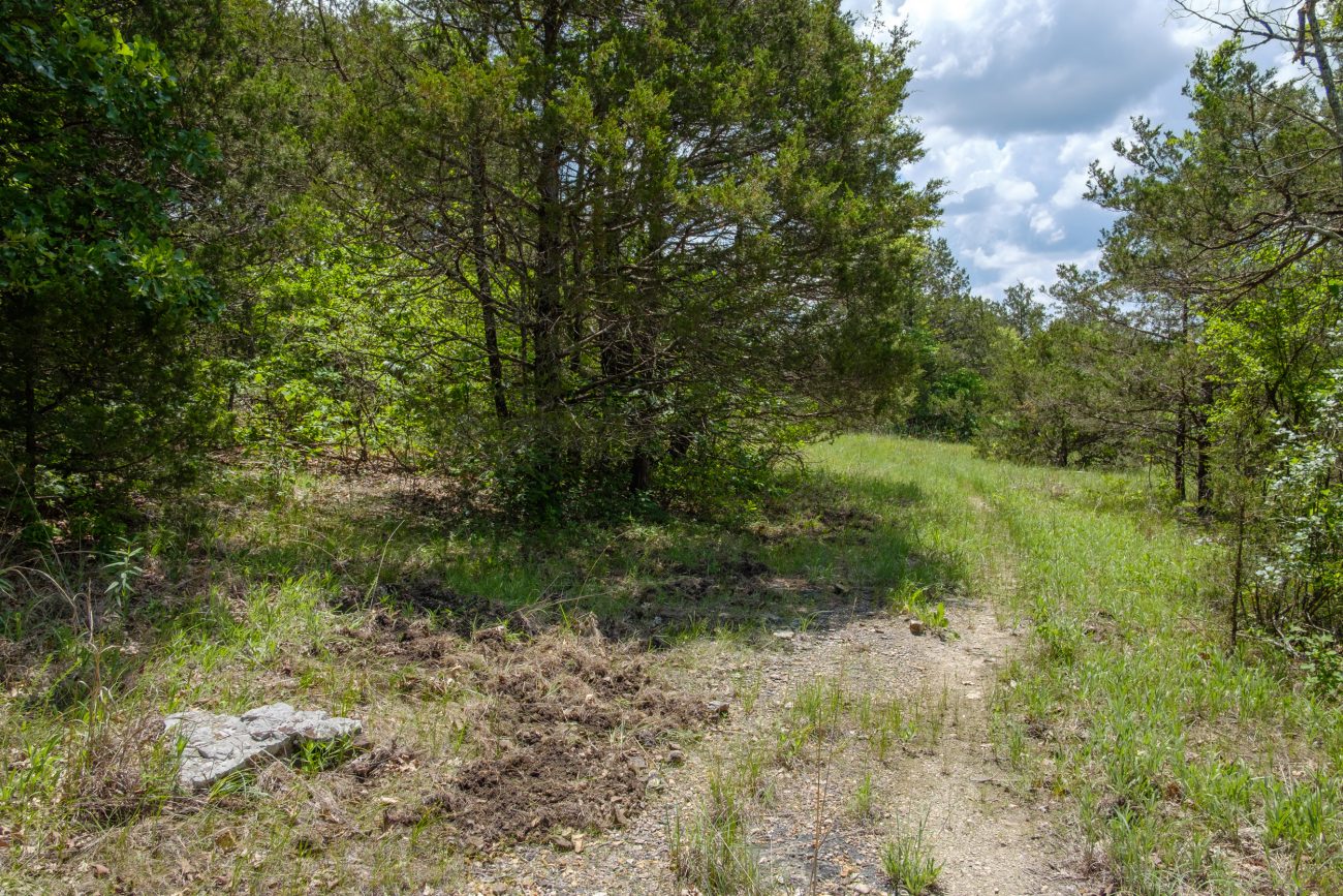
Hog Damage. Copyright © 2018 Gary Allman, all rights reserved. Near the northern end of the Lower Pilot Trail I spotted a lot of feral hog damage. It’s the first I’ve seen at Hercules Glades. I reported it to MDC when I got back, and I was told that they’ve been trapping hogs on the glades and on adjacent property. If you see signs of hogs report it to MDC so that they can get rid of them.
The hike east along the Tower Trail was uneventful, I was last on this trail in March. By 1:30 p.m. I’d arrived at the north end of the Middle Trail, and I set off downhill towards Long Creek and The Falls.
 Looking East on the Tower Trail. Copyright © 2018 Gary Allman, all rights reserved.
 Middle Trail Junction with the Tower Trail (Looking west). Copyright © 2018 Gary Allman, all rights reserved.
Along this trail I met up with three groups of students, complete with clipboards and compasses. The groups varied in size from around eight people to a single individual. They were all part of a group of geology students out of MSU on a field trip. I was told there was around 18 of them out on the trails.
 Glades on the Middle Trail. Copyright © 2018 Gary Allman, all rights reserved.
 Glades on the Middle Trail. Copyright © 2018 Gary Allman, all rights reserved.
 This is a Wilderness. Copyright © 2018 Gary Allman, all rights reserved.
 Cedars — Somewhere around here I met my first group of students. Copyright © 2018 Gary Allman, all rights reserved.
I was starting to think that any chances of being undisturbed on this trip were rapidly diminishing, especially as later on, while walking the last bit of the trail to The Falls, I noticed some people alongside the creek, and I could hear a dog and more people at The Falls.
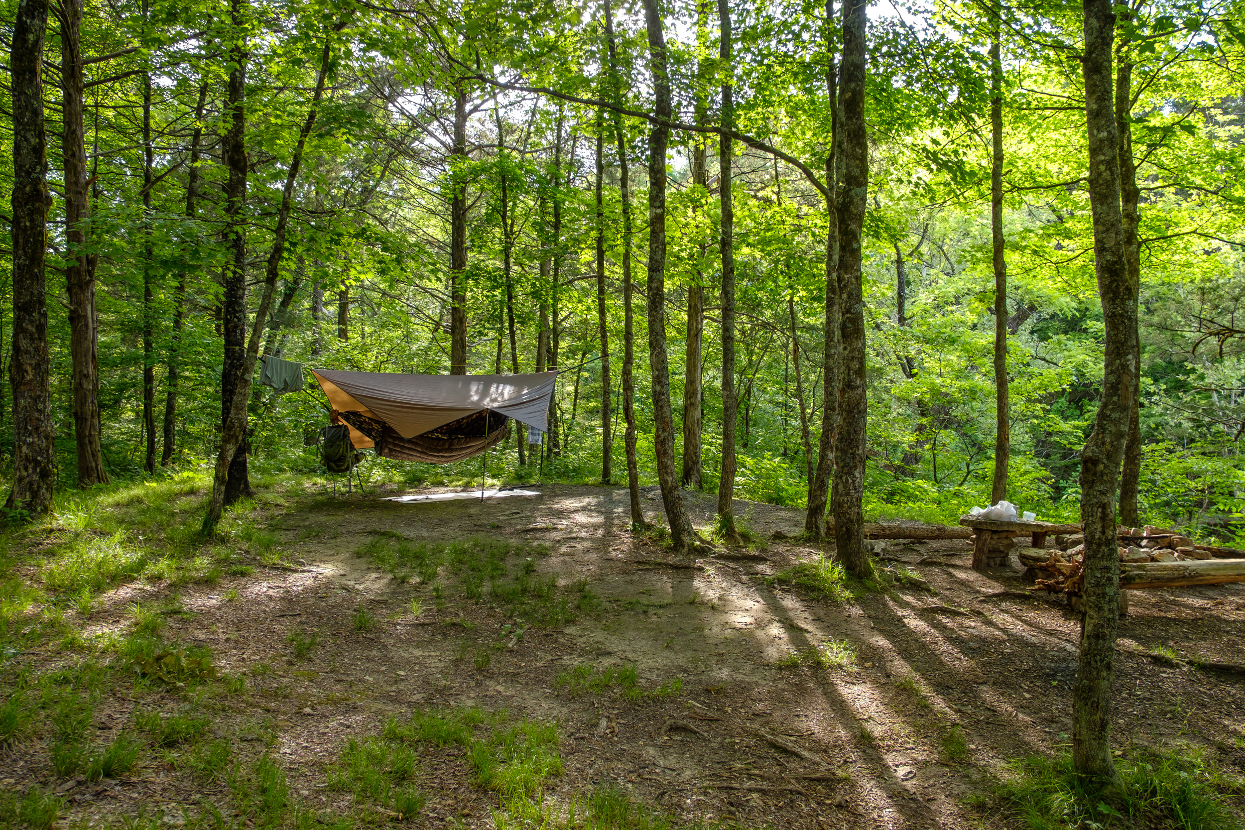
I went straight past The Falls (which weren’t running) and carried on to what I call the ‘Upper Campsite’ I think we last stayed here in September 2011. There was no one around and after a bit of a reconnoiter further along the trail, I picked my spot and took my time setting my new tarp and underquilt up for the first time.
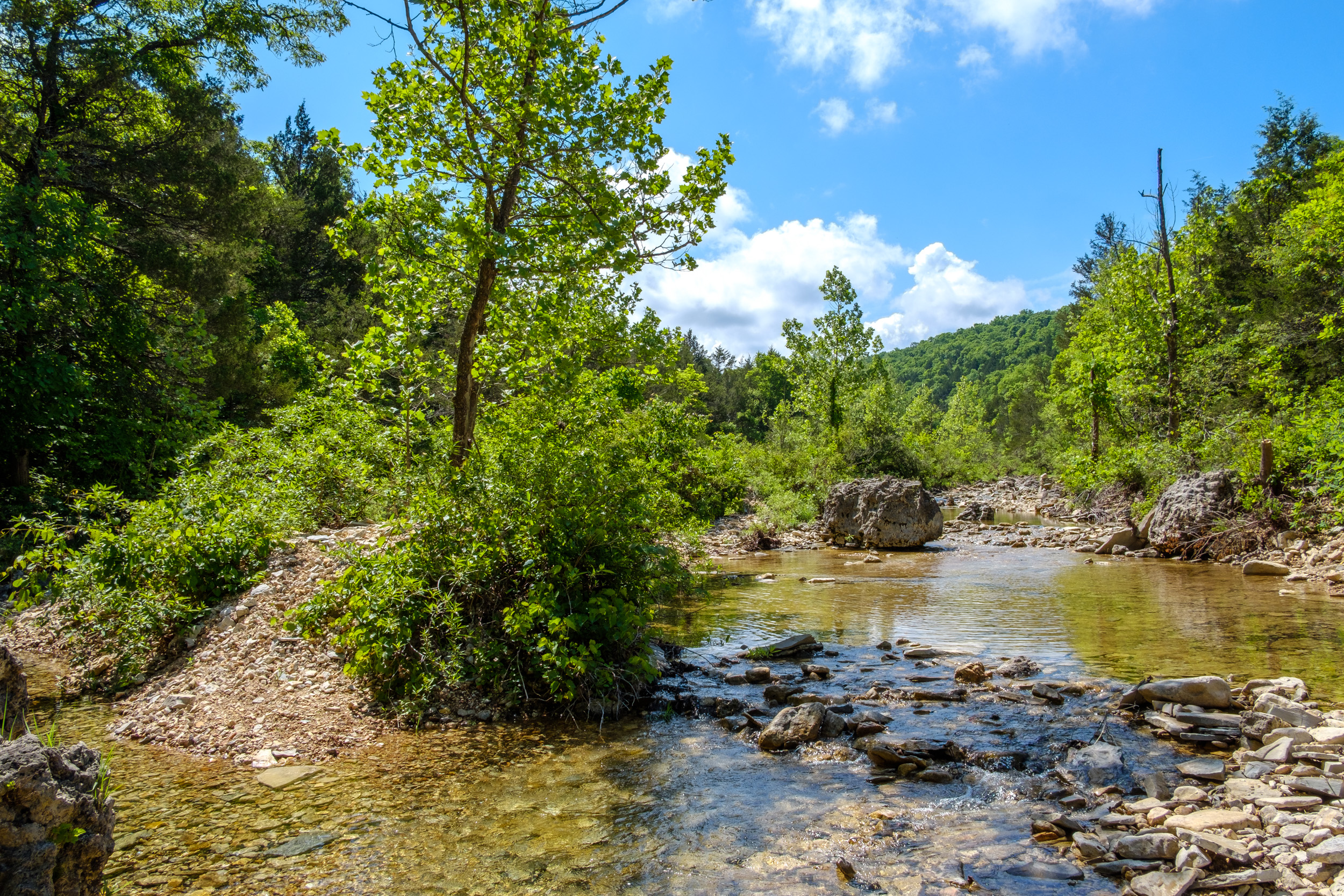
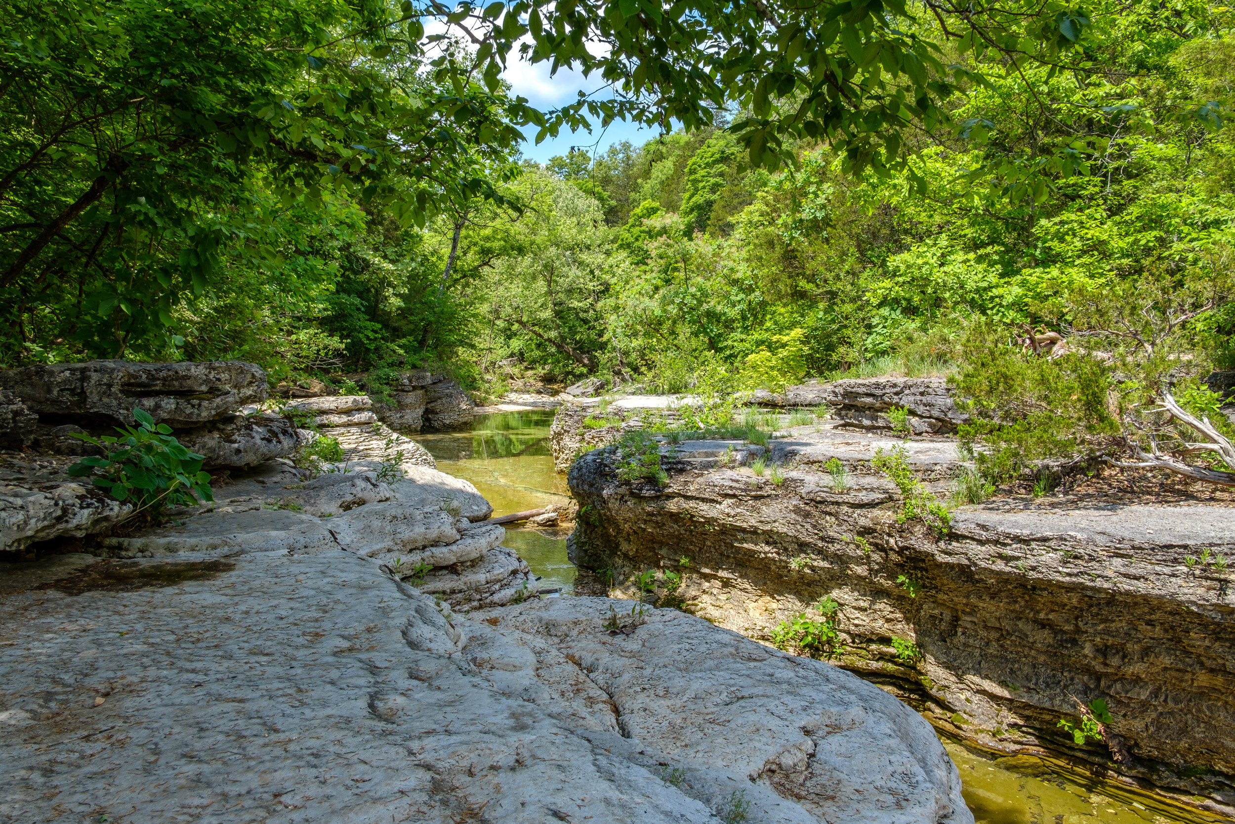
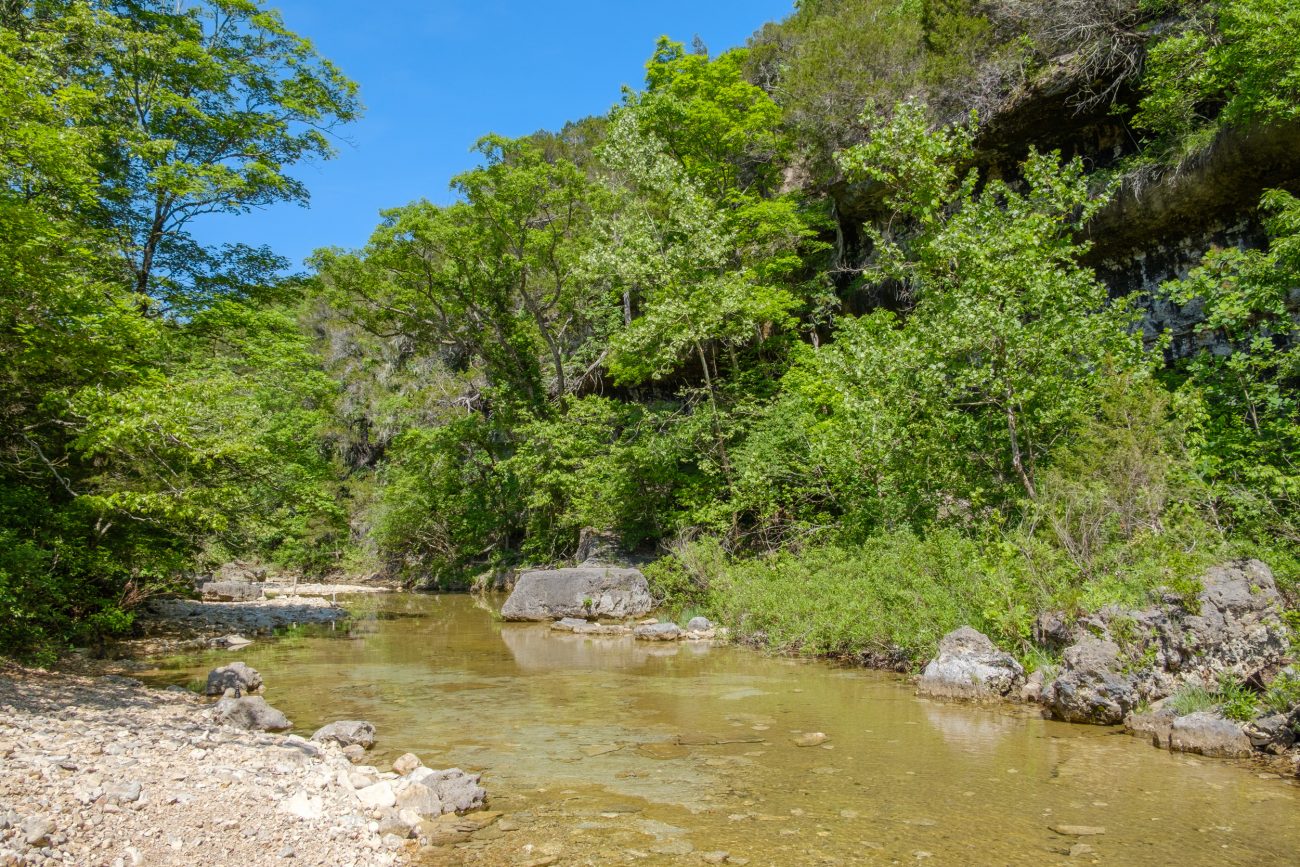
After hiking 6.3 miles I arrive at Long Creek. Copyright © 2018 Gary Allman, all rights reserved. 
After hiking 6.3 miles I arrive at Long Creek. Copyright © 2018 Gary Allman, all rights reserved. 
New Tarp and Under quilt. Copyright © 2018 Gary Allman, all rights reserved.  Hammock Camping. Copyright © 2018 Gary Allman, all rights reserved.
 Hammock Camping. Copyright © 2018 Gary Allman, all rights reserved.
The Falls are a really popular draw, and get very busy, so the impact on the area is huge. I was quite impressed by the lack of litter and mess, though it was obvious that many trees have been cut down — some to make furniture. One good thing about all the foot traffic was that it meant there was very little grass for the ticks to hide in. Even so they were out in legions, and I lost count of how many I eradicated. Despite using Deet and careful checking. I still managed to bring several home.
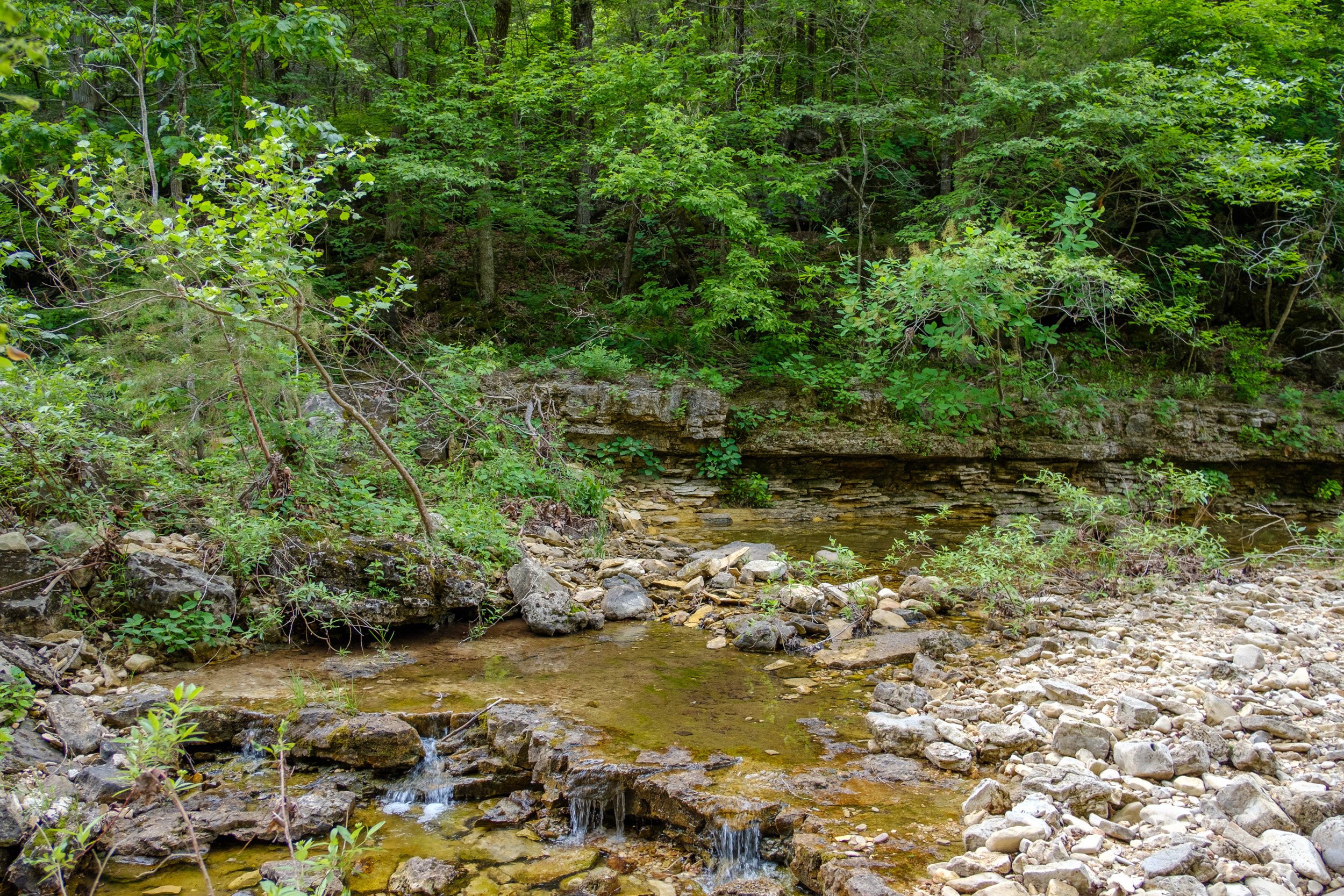
As the afternoon drew on the people disappeared until I finally had the place to myself. Which was good, as I filled up with water, and then had a (cold) bath. There was very little wood to be found (the word denuded springs to mind), but I managed a small fire to smoke some of the mozzies and bugs away.

Time for a quick bath. Copyright © 2018 Gary Allman, all rights reserved. 
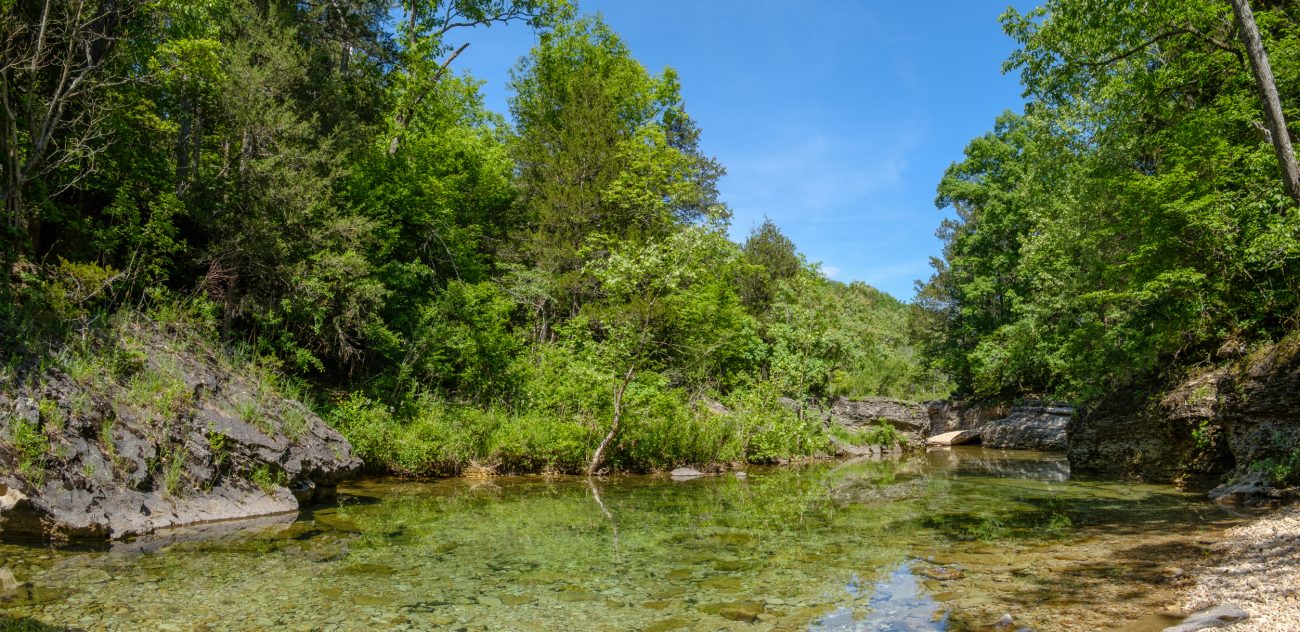
Looking Down Long Creek Towards the West. Copyright © 2018 Gary Allman, all rights reserved. 
Some Mini Falls on Long Creek. Copyright © 2018 Gary Allman, all rights reserved. For this trip I experimented with transferring my Mountain House meal out of the packet and into a Ziploc bag. It was very effective, and something I’ll be doing in future. No sharp edges (the edges of the Mountain House packets are sharp — on our last trip they punctured the Ziploc bag holding our dessert!). The Ziploc bag was smaller and more flexible, so I could roll the top down, making eating the meal easier.
By 10:00 p.m. I was in bed. My first time in the hammock without a pad, and with an underquilt. Oh my, I was surprised how different it was. Not unexpectedly, the hammock wraps itself around you, and the underquilt keeps you toasty. laying on your side is fine, as is laying on your back. Laying diagonally keeps you surprisingly flat and straight. This set up gets a huge thumbs up from me, now I just need the chance to get out more often, though the unusually hot weather we are having seems to be against that.
The day’s total: 6.3 miles with 835′ climbed and 972′ of descent, all with the temps in the mid-eighties.
Day Two
I slept in, finally waking up just before 8:00 a.m. surprised to see someone out walking their dog. So surprised that I didn’t say anything, and they quickly turned around and went back the way they’d come. That’s another reason why I’d much rather bushwhack well off the trail and wild camp a long way from the popular haunts.

What a great spot to sit and have your coffee first thing in the morning. Copyright © 2018 Gary Allman, all rights reserved. All Mod-Cons including a Flintstone-esque table at the campsite above The Falls on Long Creek. . Copyright © 2018 Gary Allman, all rights reserved. 
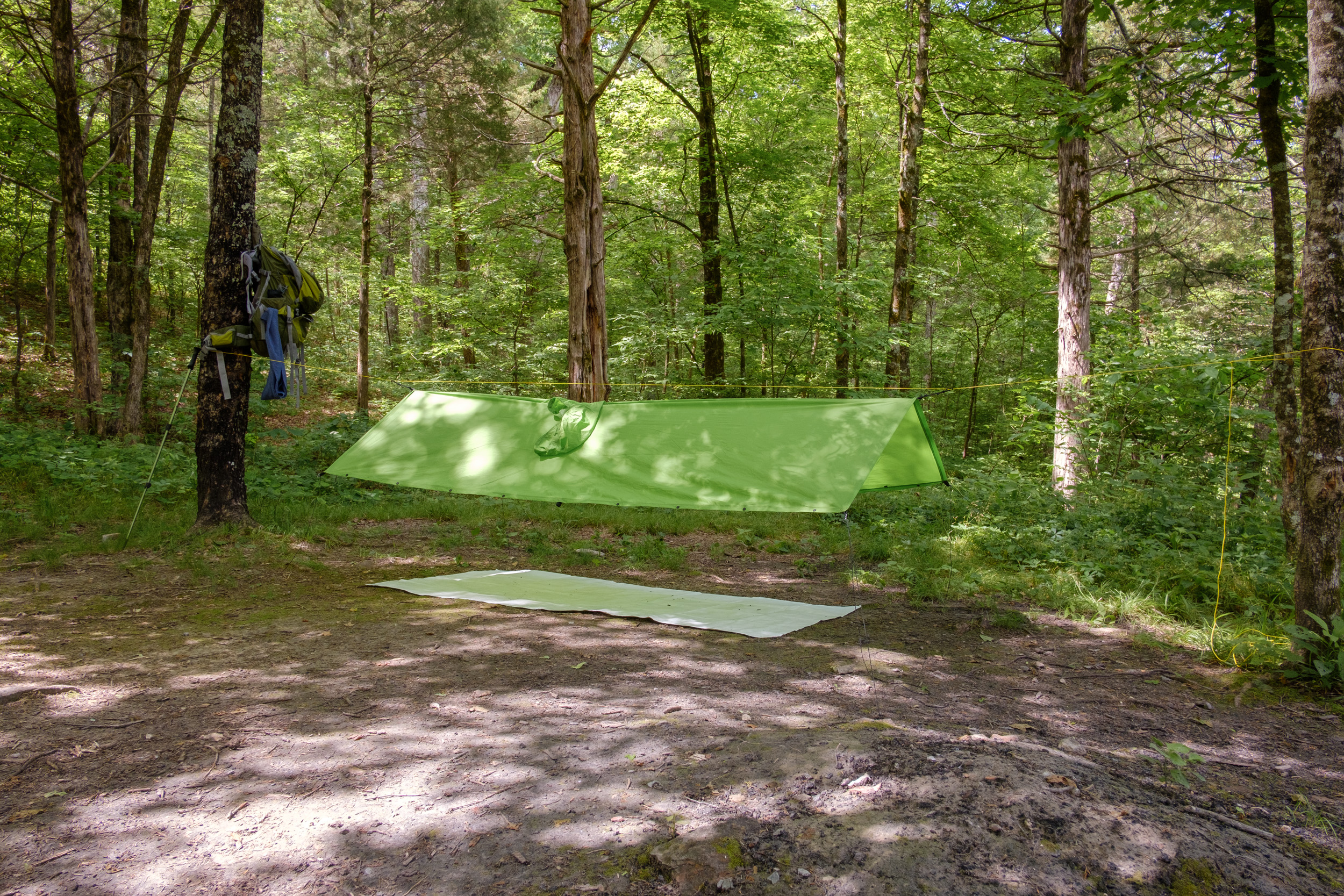
All Mod-Cons including a Flintstone-esque table at the campsite above The Falls on Long Creek. Copyright © 2018 Gary Allman, all rights reserved. I spent a very leisurely morning sitting enjoying the view and playing with my gear. After I’d taken the tarp and hammock down I tried setting up my rain poncho as a tarp. Set high enough to sit under, I think the rain would be able to get under it quite easily. Set much lower and you’d have to lie down. From the sounds of distant (and not so distant) thunder I might well have a chance to try it out on my hike out.

Wet Weather Gear Test. Copyright © 2018 Gary Allman, all rights reserved. I was all packed up and on my way shortly before Midday. As the falls weren’t running I was tempted to not bother stopping there. However, I decided to get a few photographs of the area, even if pretty pictures of cascading water were out of the question.

Long Creek Falls Campsite. Copyright © 2018 Gary Allman, all rights reserved. 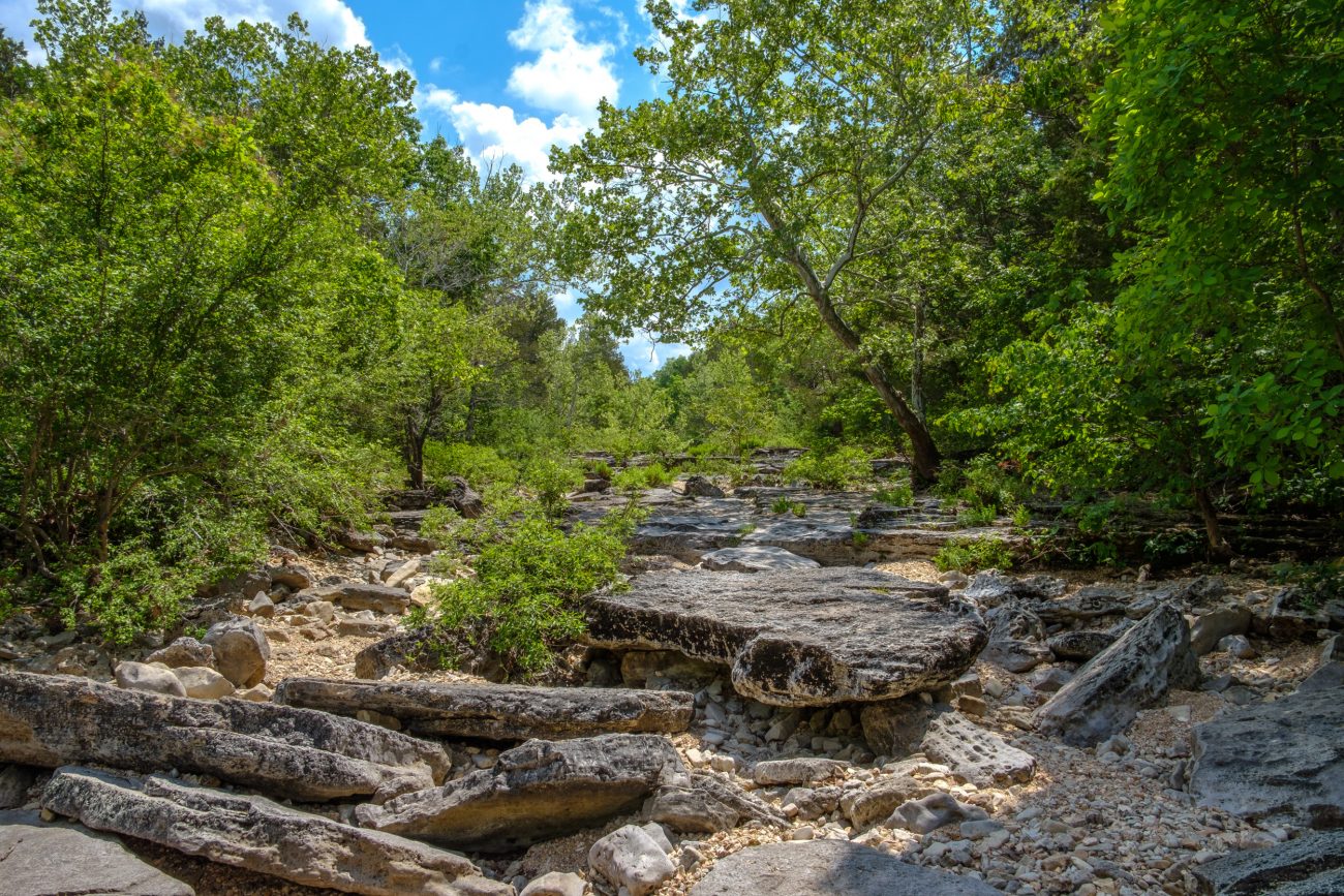
Long Creek Looking East From The Falls. Copyright © 2018 Gary Allman, all rights reserved. 
Looking West From Long Creek Falls. Copyright © 2018 Gary Allman, all rights reserved. 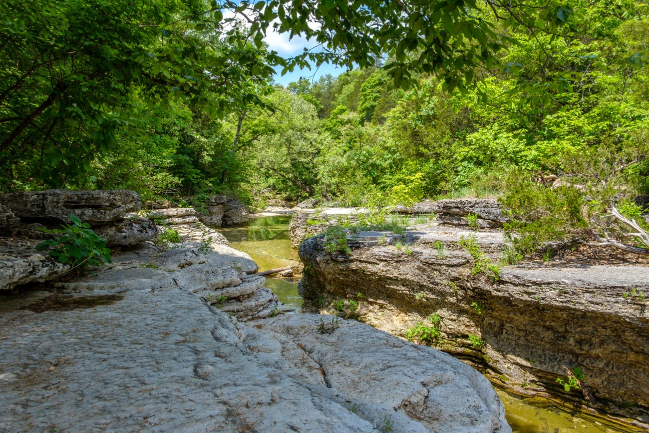
Long Creek Looking West From The Falls. Copyright © 2018 Gary Allman, all rights reserved. My trip back was as planned, via the Coy Bald Trail, which quickly rises out Long Creek’s hollow, and then goes along a ridge before skirting Coy Bald and returning to the trailhead. Hearing the thunder, I didn’t want to get caught on the top of the ridge if a thunderstorm hit, and planned to retreat rapidly downhill if that happened. The last time I sat out a storm near the Coy Bald trail, the weather radio gave us a tornado warning, and one passed by several miles to the north.
Back to the current hike, and again I surprised myself by being able to climb the hills with very few pauses. To try and keep ahead of the storms I was traveling quite quickly, though that was soon offset by stopping to take pictures along the way. I arrived back at the trailhead just after two. Four miles in two hours is fairly speedy going for me — I usually travel at an average of 1.1 miles per hour (that allows for photo stops, and other bits of exploring along the way).
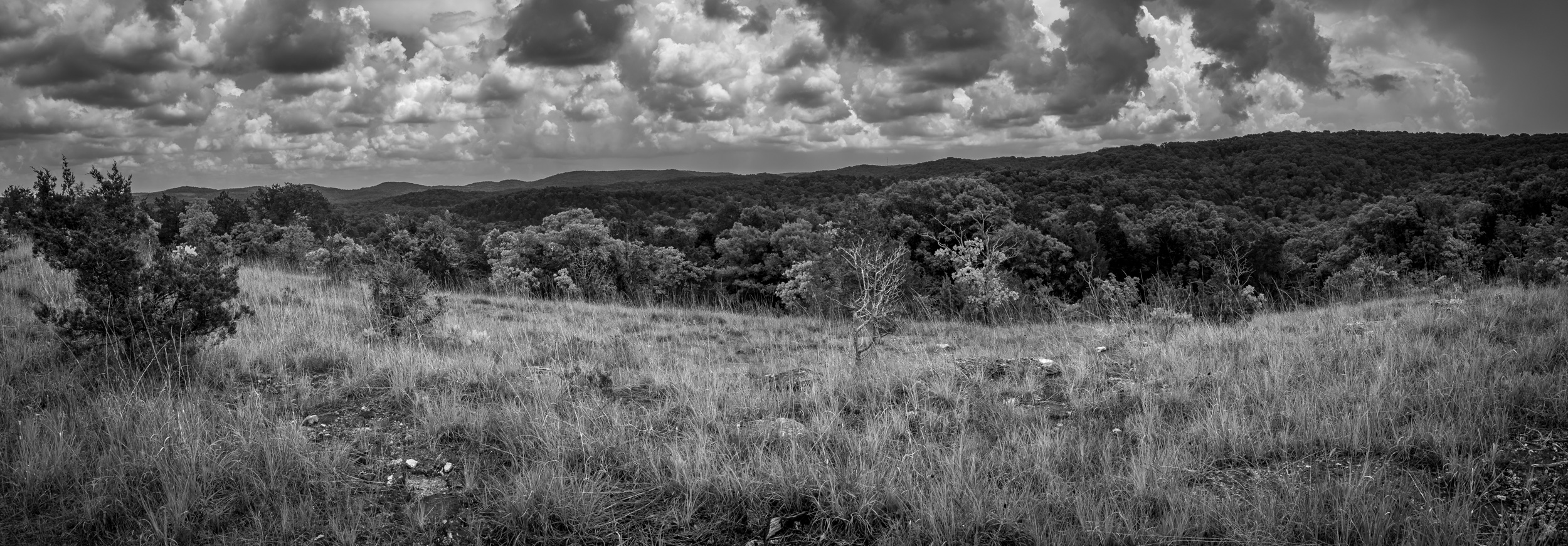
 Storm Clouds Ahead. Copyright © 2018 Gary Allman, all rights reserved.
 The first two thirds of the trail runs along a ridge. Copyright © 2018 Gary Allman, all rights reserved.
 Crossing the glades. Copyright © 2018 Gary Allman, all rights reserved.
 Looking East from The Glades. Copyright © 2018 Gary Allman, all rights reserved.
 It’s Not All Glades. Copyright © 2018 Gary Allman, all rights reserved.
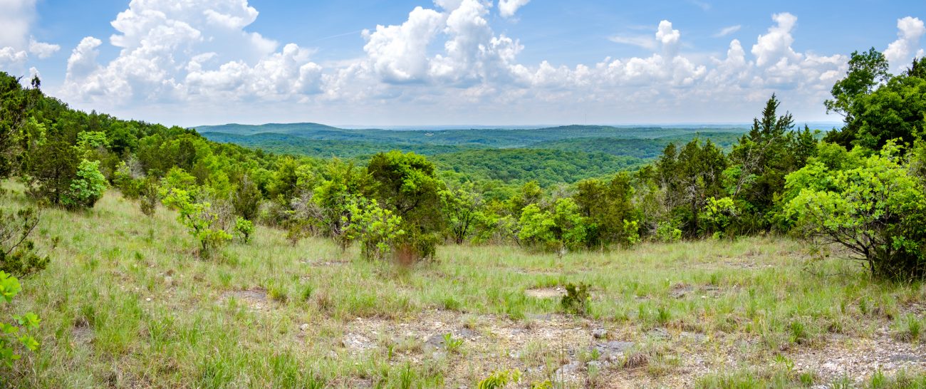
View to the South. Copyright © 2018 Gary Allman, all rights reserved. 
Ginger and I took a picture somewhere along here on December 31, 2010. I couldn’t recognize/remember the spot so this will have to do. Copyright © 2018 Gary Allman, all rights reserved. 
The Start/End of the Coy Bald Trail. Copyright © 2018 Gary Allman, all rights reserved. 
Finished! At the Wilderness Boundary. Copyright © 2018 Gary Allman, all rights reserved. The day’s total: 4 miles with 691′ climbed and 540′ of descent, with the temps mainly in the upper-eighties.
And the rain? It rained hard about twenty minutes after I’d started driving home, and lasted most of the (hour-long) drive back.
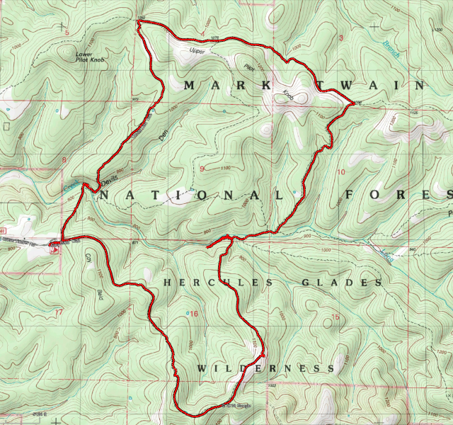
May 22, 23. Long Creek, Lower Pilot, Tower, Middle, and Coy Bald Trails. Final Thoughts
The tarp and underquilt were great, though I’ve yet to put any tarp through its paces in bad weather. However, I’m very glad to see the back of the big and heavy polypropylene tarp, and the sleeping pad.
I took a new 6′ x 3′ Tyvek ground sheet, and that was a great improvement over the smaller size I’ve been using up to now. I should have changed that up ages ago.
The jury is still out on the rain poncho, it’s a lot heavier than I expected. I had hoped that it was going to be a drop in my pack and forget item, but right now, I’m not too sure. We’ll see.
The camera clamp worked just as expected and it’s good to have a small tripod with me. I’ll probably use it more on the next trip. This time I forgot I had it until the start of the second day.
As I mentioned in the beginning, I’m going to have to take stock and see what else I can drop from my pack as I still want to reduce my pack weight and size further. As the amount I have to carry reduces, one way to save weight may involve a smaller pack. Reducing weight is one thing, but I’m not prepared to give up on my luxuries — though I’m not quite sure what classes as a luxury anymore, or even if I have any of those left! Indulgences might be a better term than luxuries at this point.
This is an edited and abridged version of a post that first appeared on Ozarks Walkabout.
-
Coy Bald Trail Panorama

View to the South – Coy Bald Trail. Copyright © 2018 Gary Allman, all rights reserved. 
Looking East from The Glades – Coy Bald Trail. Copyright © 2018 Gary Allman, all rights reserved. Black and white version of a couple of the panoramas I took, each is 4-5 frames hand-held. I’m not sure if this says more about the stitching technology or my keeping the camera steady.
-
At the end of the hike

Busiek Silver/Yellow Trail hike. Taken at the end of the hike. Copyright © 2018 Gary Allman, all rights reserved. This is a rescued image. I’d managed to flick the exposure compensation dial round to +3 stops (I only use the camera in ‘auto’ mode for selfies. I normally shoot full manual). All the color information was lost, but I managed to pull out this image by converting it to black and white.
The temperature was in the 80s, and I had just finished my hike with 920′ of elevation gain, so I’m allowed to look a little sweaty. It was a busy day on the trails — even the back ones. I saw over 20 people on the hike.
I took this with the camera upside down — it’s easier to hold the camera release the shutter single-handed that way — That’s cool, I’ve just realized it automatically flipped it the right way up when I imported it.
 The temperature was in the 80s, and I had just finished my hike with 920′ of elevation gain, so I’m allowed to be a little sweaty. Copyright © 2018 Gary Allman, all rights reserved.
 At the end of the hike. Copyright © 2018 Gary Allman, all rights reserved.
 At the end of the hike. Copyright © 2018 Gary Allman, all rights reserved.
 -
Dry Falls – Panorama

Dry Falls – Panorama