-
Jim Beam and 400 West Market

Jim Beam and 400 West Market. Copyright © 2019 Gary Allman, all rights reserved. And a slightly different take on the picture.

Jim Beam and 400 West Market . Copyright © 2019 Gary Allman, all rights reserved. -
Dish

Dish. Copyright © 2019 Gary Allman, all rights reserved. I like its rustic charm. That’s all I have to say about that.
-
Tambourine

Tambourine. Copyright © 2019 Gary Allman, all rights reserved. Because I can. And more strictly a Headless Tambourine.
How about: “We all bang on a yellow tambourine, a yellow tambourine, a yellow tambourine.” You’ll thank me for that ear-worm later.

Tambourine. Copyright © 2019 Gary Allman, all rights reserved. -
Egg

Egg – Jim Davis. Copyright © 2019 Gary Allman, all rights reserved. Another of Jim’s creations. Some wag suggested it should be called a Faber-jim egg… Apparently that wag was Ginger, and she suggested it should be “by Faber-jim, because he’s a good egg.”
-
A Week in Denver

A Week in Denver. Copyright © 2019 Gary Allman, all rights reserved. Communicators’ Conference 2019
Above you can see a few of the goodies I came away with – there were lots more. Among the items missing is the St. Augustine’s prayer book, which I am enjoying working through.
When I was asked to speak at one of the workshops, I wondered what fantastic communication feat I’d achieved to warrant the invitation. I soon found out. My given topic was romance scams.
I thought long and hard before I agreed to take part. I decided to go ahead because it was an excellent opportunity to raise awareness about romance scams. I gave a twenty-five-minute presentation as part of the cybersecurity workshop. I also wrote an accompanying article for my fellow communicators to publish. It’s already been published a couple of times, and I hope that many of my communications colleagues will include it in their magazines. The article is written from my point of view (I targeted it initially for publication in a men’s ministry magazine), but it includes information sent to me from some of the victims and their families.
You can read Unknowing Victims here.
***
Monday. Spring hadn’t properly arrived in Denver, in the evening it started to snow heavily. I braved the weather and found a good Indian restaurant a few blocks away. It was so good I returned on Wednesday to try some different dishes.
Tuesday, after our pre-conference workshops we held the conference Eucharist at St. John’s Cathedral which was followed by food provided by the cathedral. I was quite unsettled, as I called Ginger from the cathedral and we had to cut our conversation short because of a tornado warning. For whatever reason, the Springfield weather radar was down (one imagines the worse), and I couldn’t get any information. Looking on social media I could only find a severe thunderstorm warning, which was a bit of a relief. I’d have been a lot more worried if I’d found out what was happening. Nine tornadoes touched down in the area (update: the final figure was over 25), one traveling ten miles. Fortunately, no one was killed, though a lot of places have been trashed.
Wednesday was wall to wall workshops. This was a week when my photo-mojo pretty much deserted me. I struggled photographically and personally at this conference and mainly kept to myself. Rather than join in the group dinners, I went back to the Indian restaurant I’d found on Monday.
Thursday. Fortunately by the time Thursday and some free time came around the weather had improved. Still a tad on the chilly side, but much better. After I had delivered my presentation and I’d seen the second keynote speech, I visited the Denver Art Museum.
Friday was a travel day but my flight didn’t leave until 5 pm. So I wandered around town for a while before catching the train to the airport.
-
1144 15th Street, Denver, Colorado

1144 15th Street, Denver, Colorado. Copyright © 2019 Gary Allman, all rights reserved. And it was just as spectacular in color…

1144 15th Street, Denver, Colorado. Copyright © 2019 Gary Allman, all rights reserved. -
Colorado State Capitol, Denver

Colorado State Capitol, Denver. Copyright © 2019 Gary Allman, all rights reserved. The thing that struck me most about this building was the color, gray and blue. The grey is actually white marble, the blue I haven’t gotten to the bottom of yet [update. Thanks to Eddie, see below in the comments, here’s the answer: https://denverite.com/2018/02/14/why-colorado-capitol-two-colors/ ]. The cupola is copper sheet covered in gold leaf from a Colorado mine and celebrates the Colorado gold rush.
It looked a bit like a half painted Airfix kit to my eye, but I loved how the cupola popped against the clouds.
-
Denver Skyline

Denver Skyline. Copyright © 2019 Gary Allman, all rights reserved. -
An Afternoon at Denver Art Museum

Denver Art Museum. Copyright © 2019 Gary Allman, all rights reserved. Finding myself with a few hours of free time, I spent a couple of hours wandering around the Denver Art Museum.
The North building is being reconstructed, and one gallery in the open part was being fitted out for a new exhibition, so there wasn’t a lot to see. The exhibition of English Art wasn’t very inspiring. What was interesting was listening to the whoppers the guide was telling. On a Constable, she commented that almost every English home has a reproduction Constable in it. Nah. I have a horrid suspicion that you are more likely to find a copy of the ‘Chinese Girl‘ (aka the Green Lady) than a Constable (I exaggerate, but only slightly).
Nowadays my artistic interests are sated by sculpture and modern art. I think I’ve overdosed on the classical paintings during recent trips, and they are all looking rather samey. What a heretic I am.
The sculptures located outside were very uninspiring. A couple of twee concrete seats that wouldn’t have looked out of place in a garden center, and a row of boxes. Fortunately, the architecture of the building itself gave me some inspiration.
The Jordan Casteel exhibition was interesting. I found her subjects’ large eyed direct stares very compelling.

Reflections. Copyright © 2019 Gary Allman, all rights reserved. The above image is of some of the windows being installed in the new North Building. The curvature seems to be carefully designed to make the reflections move in an eye-catching manner. I couldn’t capture the movement with the camera, so I suspect there are some interesting 3D optical illusions being employed.
-
Portal to another dimension

Portal to another dimension. Frederic C. Hamilton Building. Denver, Colorado. Copyright © 2019 Gary Allman, all rights reserved. Originally I edited out the access doorway as I thought it distracting, but I had a change of heart and left it in. It reminded me of the movie ‘Being John Malkovich.’
-
Made in China. Artist: Sui Jianguo

Made in China. Artist: Sui Jianguo. Copyright © 2019 Gary Allman, all rights reserved. I think it was the color and the size that attracted me to this. The collection notes say that it is a large-scale copy of a toy dinosaur. It looks a bit more like Godzilla than a t-rex to me.
I must admit that my camera struggles with over-saturated reds like this so I needed to tweak the color (a lot) in post production.
-
Skylight

Skylight – Seen at Denver Art Museum, Frederic C. Hamilton Building.Copyright © 2019 Gary Allman, all rights reserved. I really cannot remember which way was ‘up’ when I took this picture. I remember lining up the dark area at the bottom of the frame, but in which direction it went I have no recollection.
Denver Art Museum – Frederic C. Hamilton Building. Architect: Daniel Libeskind.

Skylight – Seen at Denver Art Museum, Frederic C. Hamilton Building. Copyright © 2019 Gary Allman, all rights reserved. -
The Way the Moon’s in Love with the Dark, Artist: Fred Wilson

The Way the Moon’s in Love with the Dark, Artist: Fred Wilson. Copyright © 2019 Gary Allman, all rights reserved. I should have tried a video and/or stereo picture of this piece. It is huge (6.5ft tall and 4.5ft across). Even so, it was looking rather lonely in the gallery, where it was almost the only exhibit. The highly polished black finish and the mass of lights and delicate details were quite mesmerizing.
For some reason, it reminded me of the movies Alien and Dark City. Probably because both are dark and have gothic elements.
Read more: The Way the Moon’s in Love with the Dark, Artist: Fred Wilson


-
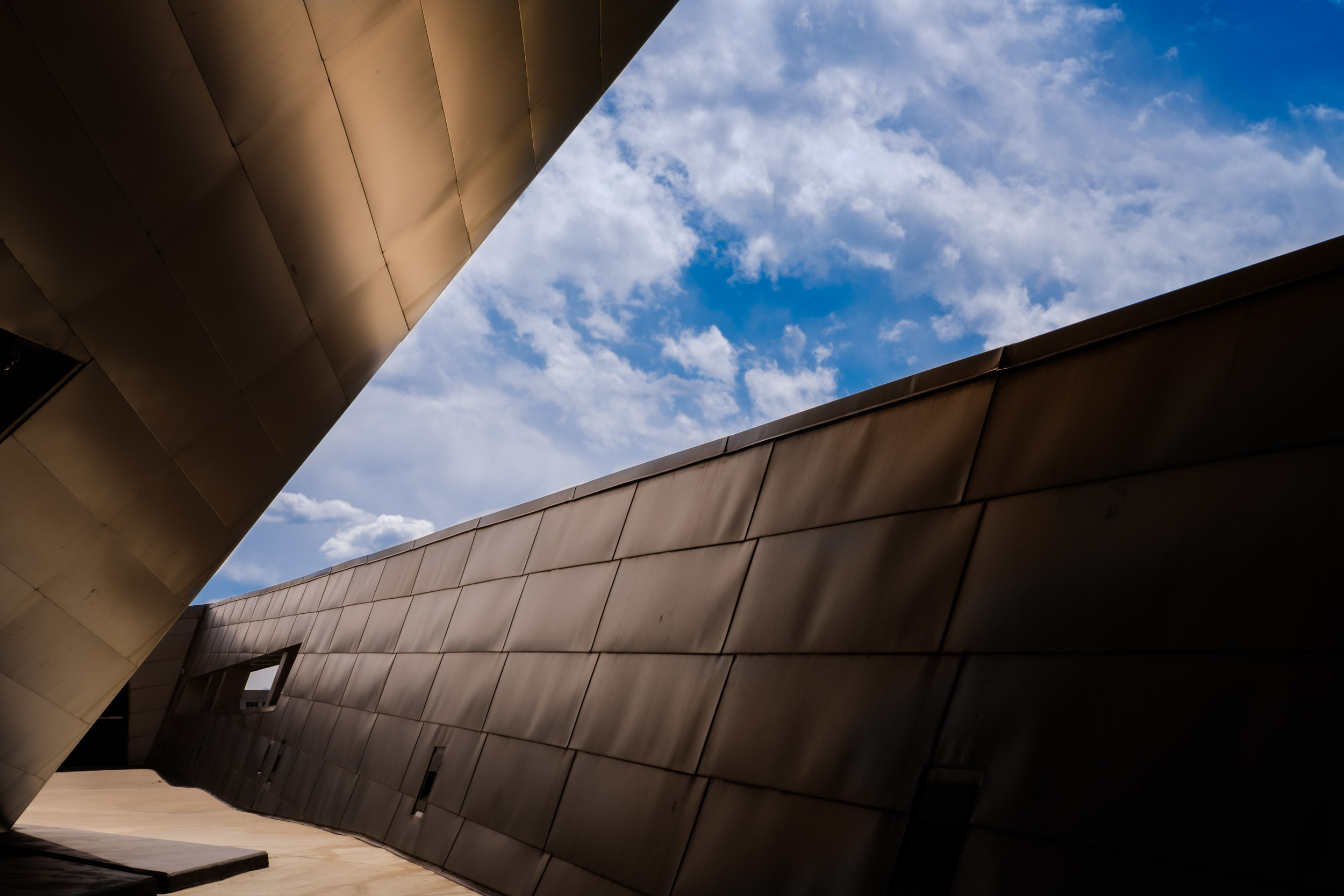
Contrasting Spaces #1

Contrasting Spaces #1 – Denver Art Museum. Copyright © 2019 Gary Allman, all rights reserved. I’ve been struggling on this trip. Spying this image broke — at least temporarily — the joint curses of a lack of photo-mojo and “I can’t give a fuckedness.”
The light glowing on the titanium paneling was what first drew my eye. Then I had to find an angle that worked to remove the visual clutter of the surrounding buildings and left out the doorway into the museum.
Denver Art Museum – Frederic C. Hamilton Building. Architect: Daniel Libeskind
-
Contrasting Spaces #2

Contrasting Spaces #2 – Denver Art Museum. Copyright © 2019 Gary Allman, all rights reserved. Whatever I said about Contrasting Spaces #1, plus I can’t choose between the color and black and white versions.
Denver Art Museum – Frederic C. Hamilton Building. Architect: Daniel Libeskind.
-
Curtis Hotel, Denver Colorado

Curtis Hotel, Denver Colorado. Copyright © 2019 Gary Allman, all rights reserved. I need a wider lens. I could have gone closer, so I was shortening the angle, and so fitted the entire building in, but that would have involved standing in the middle of the road. I couldn’t move back any further because of street furniture (lamposts and trees to everyone else) would start to intrude on the image, and I was backing up into the building behind me — the Opera House. To be honest I couldn’t be bothered just for a snapshot of the hotel.
I can see my room though, I thought by getting a room on the sixteenth floor I’d be able to see mountains. Nah, all I could see was the building opposite.
-
Holy Communion at St. John’s Cathedral. Denver, Colorado

Holy Communion at St. John’s Cathedral. Denver, Colorado. Copyright © 2019 Gary Allman, all rights reserved. The conference opening Eucharist was held at St. John’s Cathedral. Notice how the incense is managing to fill this huge space.
Below is a look at the opposite end followed by a view from the gallery.

St. John’s Cathedral. Denver, Colorado. Copyright © 2019 Gary Allman, all rights reserved. 
St. John’s Cathedral. Denver, Colorado. Copyright © 2019 Gary Allman, all rights reserved. -
Censing the Altar

Censing the Altar. Bishop-Elect Kimberly (Kym) Lucas Copyright © 2019 Gary Allman, all rights reserved. 
Censing the Altar. Bishop-Elect Kimberly (Kym) Lucas Copyright © 2019 Gary Allman, all rights reserved. -
Prayer Candles, St. John’s Cathedral Denver, Colorado

Prayer Candles, St. John’s Cathedral Denver, Colorado. Copyright © 2019 Gary Allman, all rights reserved. -
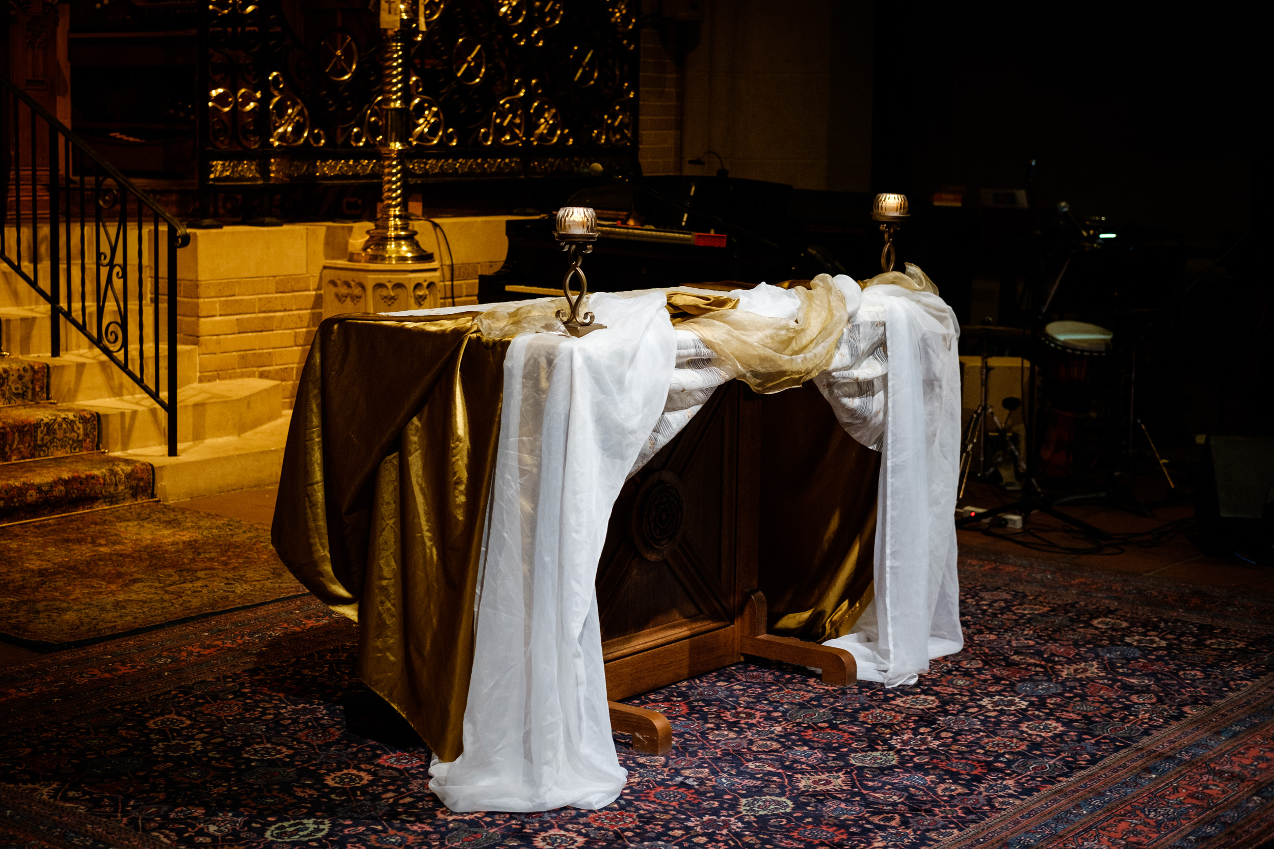
Altar

Altar – St. John’s Cathedral. Denver, Colorado. Copyright © 2019 Gary Allman, all rights reserved.