
Trails snacks for the day and some exploring. +1
Words and pictures featuring Missouri
Trails snacks for the day and some exploring. +1

Day Two – Camped above ‘Deep Hollow,’ in the sunshine this time — everything is pretty much as I left it when I was last here in August last year. I was late to sleep, so I slept in this morning. It’s almost noon already.

Dusk at Hercules Glades Wilderness and some Shenanigans on the trail — On the Pilot (Tower) Trail at Hercules Glades Wilderness. Definitely time to turn on my headlamp. No more pictures, because — darkness — but my night hike was not without incident, and you’ll have to read the full post to find out what happened. 10-minute read.

Sunset Glow — On the Pilot (Tower) Trail at Hercules Glades Wilderness. I’m going to have to turn on my headlamp soon.

Dusk at the Pole (Pete) Hollow Trail cairn — Right on target, 25 minutes from the trailhead.

Sunset on the trail — Five minutes into my hike and the sun has almost dropped below the horizon.

Setting off — Here I am back at the Hercules Glades Tower Trailhead about to set off on my first backpacking trip of 2023. I am planning on spending two nights in the Hercules Glades Wilderness, starting with a six-mile night hike.
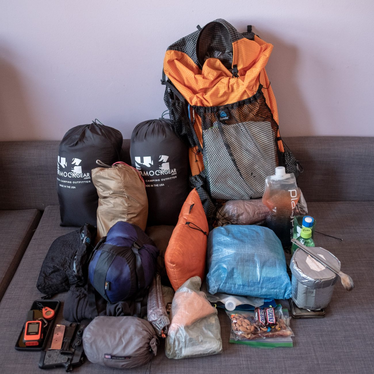
Packing for my first backpacking trip of 2023 — The temperature is forecast to vary from the mid-twenties overnight Saturday to the mid-sixties on Monday, so it is a full winter load-out plus some spring additions. The whole lot including food, water, and fuel weighs in at around 26 lbs. +4

Guilty – We are cat-sitting our ‘grandcat’ Dick for a couple of months. This was, I suspect, Dick’s way of letting me know it was well past food time.

Journal: Four days on the Ridge Runner Trail & the Devil’s Backbone Wilderness, December 2022 – Work has been keeping me off the trail for too long. I took three days of comp time to get out in the wild and put a few miles under my belt. I’ve been wanting to revisit the Ridge Runner Trail North Fork Loop ever since I first hiked the trail in May 2020. Journal: 10 42

End of trip selfie – and a summary of the trip. Three-minute read, +4

State Highway CC Wrangler Trailhead, Mark Twain National Forest, Missouri. +2

McGarr Ridge Trailhead, Devil’s Backbone Wilderness, Mark Twain National Forest, Missouri – Approaching the McGarr Ridge Trailhead. Almost at the end of my hike. +2

Looking up ‘Camp Hollow,’ the hike out, and more horses – It took me an hour to get to this spot, about two-and-a-half miles from McGarr Spring. I’ve named this hollow ‘Camp Hollow’ because, surprise, surprise, I’ve camped here a couple of times.

McGarr Spring, and on my way again – I had plenty of water for my hike out, so I didn’t need to collect any. The main Spring is located up the hill a ways and it drains down into this pool which is slowly filling with debris. It was a lot more ‘pool-like’ when I first came here a couple of years ago.

While I was getting breakfast ready it started to snow. I then spent a quiet morning enjoying the solitude until I was visited by a bunch of people on horseback. Two-minute read

Morning view from my hammock.
Keeping warm in my hammock — The low was 23°F (-5°C), well within the 10°F rating of my quilts. I was nice and cozy. A forecast of 20°F is my lower limit, I do this for funsies, not to prove anything.

The forecast Lied. Again – And a couple of early morning passers by. Start of Day Four. It was 23℉ overnight – A bit cooler than the pre-trip forecast of 31℉, and I did not set my tarp last night.

Camped above McGarr Spring, Devil’s Backbone Wilderness. Near the end of the third day of my trip. I surprised myself with an 8 mile hike today. Not bad. Four-minute read, +1

Another view of the North Fork River – I took this picture because it seemed to be pretty much where I took a picture the last time I hiked this trail. +1

The trail here is not for the faint-hearted – Not only is the drop-off steep but so is the trail. It drops 300ft in three-tenths of a mile. I don’t think I’d like to hike this trail clockwise and have to climb up it.

Selfie on the bluffs overlooking the North Fork River – Being so high up, I checked for cell service, and immediately received some messages on WhatsApp from my daughter-in-law in the UK. So I took a quick selfie to show the folks where I was. I still forget to look at the darned lens when I’m taking a selfie with my phone.

The North Fork River from the Ridge Runner Trail North Fork Loop – The bluffs here are impressively high (well they are to me). I was glad that the trees had shed their leaves, otherwise, the views would have been pretty boring.