-
Whites Creek Cave

Despite the sign, all caves (and mines) are closed because of White Nose Syndrome. This is the only sign I’ve seen with an apostrophe in White’s. Copyright © 2021 Gary Allman, all rights reserved. 
Whites Creek Cave, from Whites Creek Trail. Copyright © 2021 Gary Allman, all rights reserved. The short steep climb was rewarded by arriving at Whites Creek Cave (the only place on either map or sign that I have seen an apostrophe in White’s). The cave, like all of Missouri’s caves and mines, is closed to protect the bats from the spread of White Nose Syndrome.
I did peer in through the railings to see if I could see anything though! I couldn’t, but by the wonders of technology (my camera and my headlamp) I was able to take a picture of the inside.
-
Looking back down the trail

Looking back down the trail – the trail turns up the hill here (you can just about make it out in this picture). Most people (including me) appear to miss this. The official trail marker is not particularly helpful either. Copyright © 2021 Gary Allman, all rights reserved. Looking back down the trail – the trail turns up the hill here (you can just about make it out in this picture). It is quite a scramble. Most people (including me) appear to miss this. I wondered if it was the trail, but the path going straight on (behind the camera) was very well-trod. I only went twenty feet or so before I decided to go back and check whether the trail was coming down the hill or if it was just a water run-off channel. The official trail marker is not particularly helpful either. It suggests you should go straight down the drop-off.
-
Heading up towards Whites Creek Cave

Heading up towards Whites Creek Cave – the trail is narrow and the drop-off steep. It appears that most people miss where the trail turns left up the hill to the cave. Copyright © 2021 Gary Allman, all rights reserved. -
Back on the Whites Creek Trail

Whites Creek Float Camp spur trail (branching right in the foreground). Copyright © 2021 Gary Allman, all rights reserved. Time to head back to the trailhead, seven and-a-half miles of hiking and lots of rain in my future.
-
‘eek Float Camp

‘eek Float Camp – signs that there has not been a lot of maintenance for a while. Copyright © 2021 Gary Allman, all rights reserved. Back on the Whites Creek Trail
-
Crossing Whites Creek

Crossing Whites Creek. Copyright © 2021 Gary Allman, all rights reserved. You have to cross Whites Creek to get back to the main Whites Creek Trail. It’s not very obvious in this picture (or in reality), but the trail climbs up the bank just to the right of the tree on the left side of the frame.
The creek was around knee-deep at this point. Refreshing was a word that sprang to mind. Well, one of the words that sprang to mind while making the crossing.
-
Day Three: Change of Plan (And an unloved wilderness registration point)

Abandoned wilderness registration point. Copyright © 2021 Gary Allman, all rights reserved. My original plan for today was to hike part of the southern loop of the Whites Creek Trail and stop for the night near one of the big pools that form on Whites Creek. Then I’d have an easy three or four-mile hike out on Monday – easy except that part of the trail has most of the elevation gain!
Yesterday afternoon, through the wonders of my Garmin InReach satellite communicator, I got a message from Ginger letting me know that the kids were going to descend on us for dinner Monday afternoon. Knowing that the car would be needed in Springfield to get the necessary vittles, and my help would be appreciated, I had two choices. I could either hike out a day early or make a very early start Monday so I would be home early enough to help. Irish Wilderness is 138 miles, and two-and-a-half hours from home. Five miles hiking would take three hours, so to arrive at midday, I’d need to be on the trail by six-thirty in the morning and to do that, I’d need to be up between five and five-thirty.
I didn’t like the sound of that, so I decided I’d hike the seven-and-a-half miles back to the trailhead today. In the rain. Because, as luck would have it today is forecast to be this trip’s rainy day, which was another reason why I originally only planned on going two or three miles today.
So, here I am at twenty past ten (that’s an early start for me!) on a Sunday morning, already on the trail, at the wilderness sign-in point on the spur trail leading to the Whites Creek Float Camp, making my way back to the Whites Creek Trail. It doesn’t look like the registration point has been tended to in quite a while.
-
Time for a nice cup of hot chocolate

A nice cup of hot chocolate. My camp chair turned out to be much more comfortable than the picnic table. Copyright © 2021 Gary Allman, all rights reserved. Cadbury’s Hot Chocolate, of course.

A nice cup of hot chocolate. My camp chair turned out to be much more comfortable than the picnic table. Copyright © 2021 Gary Allman, all rights reserved. -
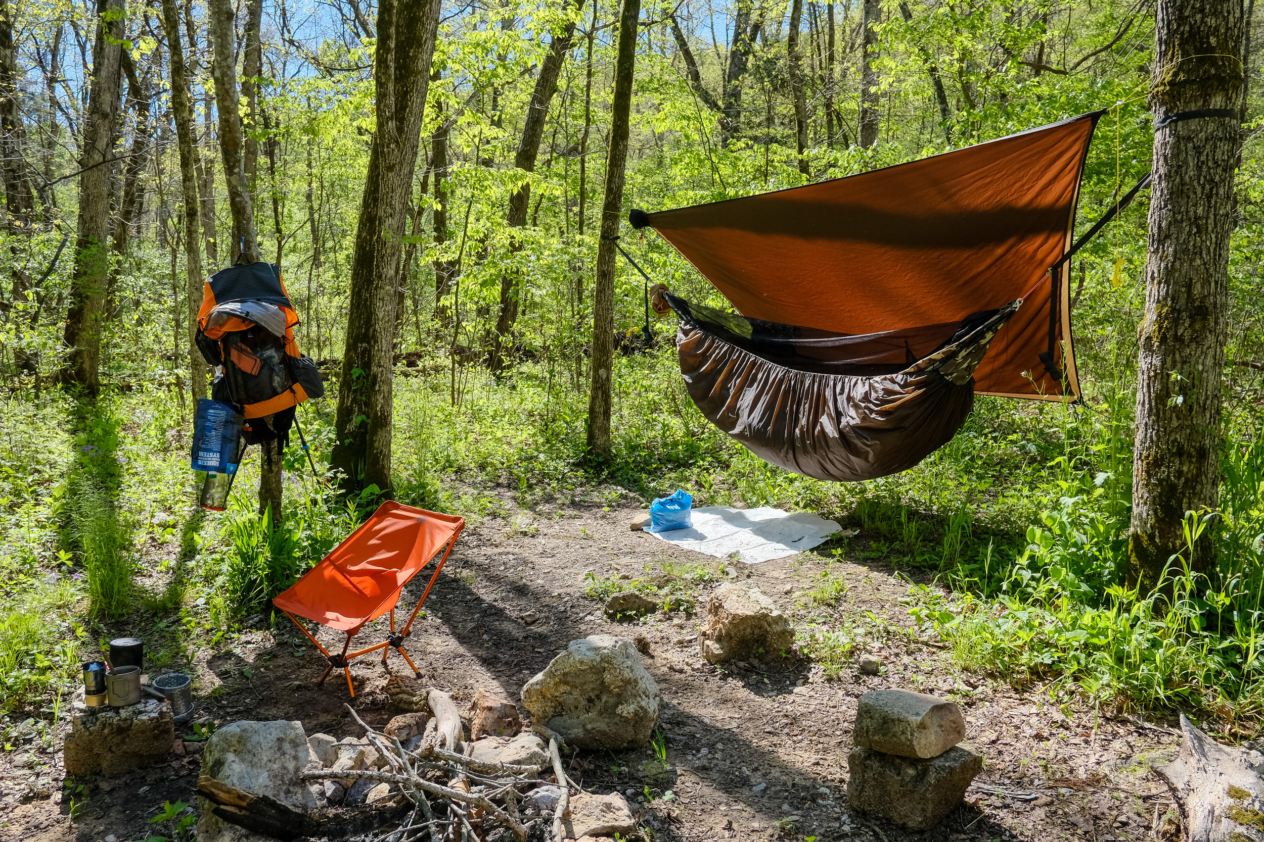
I have a picnic table and a grill!

I have a picnic table and a grill. When I found this empty float camp with a picnic table I knew I’d found my spot for the night. Copyright © 2021 Gary Allman, all rights reserved. 
Float camp hammock camping. Copyright © 2021 Gary Allman, all rights reserved. -
Path from the put-in to the float camp

Path to the float camp. Copyright © 2021 Gary Allman, all rights reserved. -
Whites Creek at the Whites Creek Float Camp

Whites Creek at Whites Creek Float Camp. Copyright © 2021 Gary Allman, all rights reserved. Whites Creek Float Camp looks to be abandoned, but I’m guessing it is just showing a lack of TLC brought on by a year of neglect because of COVID-19.
Float Camp equals an unexpected bonus. Picnic tables and grills!


-
Caves on Whites Creek

Caves on Whites Creek – currently inaccessible. Copyright © 2021 Gary Allman, all rights reserved. When the creek is low and the caves are not closed state-wide due to white-nose syndrome, you can explore them. Unless I fancied swimming I wasn’t going to get a closer look on this trip.
Getting here isn’t easy…
It’s not particularly hard work, but the trail is very difficult to follow or non-existent. So be prepared for a load of bushwhacking, and some woodland navigation.
Going counterclockwise from Bliss Spring, the first part of the trail is quite rugged and runs along a ridge-end or bluff with a (very) steep drop-off down to the Eleven Point River. You will not want to take a fall here. Once past the bluffs, the trail heads east, crosses the top of a large hollow, and then heads back west towards the Eleven Point River. I had a lot of trouble finding and keeping on the trail in this section. The descent down to Whites Creek is steep, but there are plenty of switchbacks to keep it manageable.
Once down to Whites Creek, you cross the creek, and then the trail follows alongside Whites Creek, and you come to the caves pictured above. Carry on along the trail to get to the junction and spur trail to Whites Creek Float Camp.
-
Eleven Point (Wild and Scenic) River

Eleven Point Wild and Scenic River. Copyright © 2021 Gary Allman, all rights reserved. This is pretty much the only overlook in the entire 20-mile Whites Creek Trail. The trail here is very narrow and rough with a 100+ft. drop-off on one side.
What’s with the (Wild and Scenic) stuff? Nothing. Except that’s how it’s listed on the map. I think it’s a tad daft. Strictly speaking, it’s the Eleven Point River, and the area is called the Eleven Point Wild and Scenic River.

It’s a long way down – to the Eleven Point River, which can be glimpsed through the trees below me. Copyright © 2021 Gary Allman, all rights reserved. -
This is not the trail you are looking for…

That is not the trail you are looking for … You would think (and I and many, many others have), that the trail goes straight on here. Not so. Look carefully and there’s the trail, two feet in front of the sign on the left going up the hill. Copyright © 2021 Gary Allman, all rights reserved. You would think (and I and apparently, many, many others have), that the trail goes straight on here. Not so. Look carefully and there’s the Whites Creek trail, two feet in front of the sign on the left going up the hill.
The (wrong) trail leads to a nice campsite with a view of the Eleven Point River and some old ruins, so I’m not going to complain about my navigational blunder. This was, however, the first indication that the trails on the southern loop of the White’s Creek Trail were going to be a little bit more challenging to follow.
The picture below shows the trail in the opposite direction with the spur trail to Bliss Spring on the left. The sign purports to mark the Irish Wilderness and Eleven Point Wild and Scenic River boundary – I think this is more of a virtual boundary, as according to the map, the real boundary is further east.

Irish Wilderness and Eleven Point Wild and Scenic River boundary. Copyright © 2021 Gary Allman, all rights reserved. -
Campsite by the Eleven Point River

Campsite by the Eleven Point River. I followed the trail, that I thought was the Whites Creek Trail to this campsite. I took a couple of pictures and then went back to Bliss Spring to work out where I went wrong. Copyright © 2021 Gary Allman, all rights reserved. -
Old homestead chimney

Old homestead chimney. Copyright © 2021 Gary Allman, all rights reserved. I presume this ruin dates back to the American Civil War era (1861-1865). The house would have had a nice view of the Eleven Point River. I was hoping there was a way back to the main White’s Creek Trail from here. If there was I didn’t find it. Instead, I backtracked all the way back to Bliss Spring.
-
Camped at Bliss Spring

Camped at Bliss Spring. Copyright © 2021 Gary Allman, all rights reserved. 

-
Bliss Spring (Second spring)

Copyright © 2021 Gary Allman, all rights reserved. 
Copyright © 2021 Gary Allman, all rights reserved. -
Bliss Spring

Bliss Spring, Irish Wilderness, Missouri. Copyright © 2021 Gary Allman, all rights reserved. 
Bliss Spring, Irish Wilderness, Missouri. Copyright © 2021 Gary Allman, all rights reserved. -
Day Two: Bliss Spring (video)
Bliss Spring has to be seen and heard, so I recorded a short video. Unfortunately, it’s a bit shaky in places. I was using my tiny tripod tied to a hiking pole to keep the camera steady. I wasn’t always successful at keeping things smooth.