-
Dry creek bed

Dry creek bed. Copyright © 2021 Gary Allman, all rights reserved. 
Despite the recent rain, the creeks were dry. Copyright © 2021 Gary Allman, all rights reserved. So much of my hope for finding water on the eastern side of the loop. There are a couple of stock ponds if you are that way inclined. I prefer running water.
-
Loadsa trailblazes

Ozark Trail, Ridge Runner, and North Fork Loop trailblazes. Copyright © 2021 Gary Allman, all rights reserved. From top to bottom: Ozark Trail, Ridge Runner Trail, North Fork Loop Trail.
I think I only saw five or so Ridge Runner trailblazes. The Ozark trail blazes were every few hundred yards and in some places every few yards. The North Forth Loop Blazes were every few hundred yards or so unless they weren’t. And their most notable absences were at places where the potential for confusion seemed to be the greatest. If you are hiking the North Fork Trail, you’ll need a GPS, and if you can find a recent GPS route good for you. I ended up bushwhacking quite a way along the previous route of the trail, not knowing it had been moved, and because there were no blazes at a vital point to set me off in the right direction.
-
Ozark Trail, trailblaze

Ozark Trail Blaze – The Ozark Trail Association gets my unreserved thanks. They do a great job. Copyright © 2021 Gary Allman, all rights reserved. This picture needs some out-of-focus hikers on the trail to really make it zing. I didn’t meet any hikers, though, in or out of focus on this trip.
-
Ribbit, ribbit. Toad, in a hole

Toad, in a hole. I saw one of its friends too. Copyright © 2021 Gary Allman, all rights reserved. Last night when I was staking out my tarp I noticed a small hole near where I put one of my stakes. Apart from inquiring “Anyone at home?” I didn’t think anything of it. This morning when I came to pull up the stakes, I found this chap in-residence. I later saw another hopping around. There might not be any running water about, but it seems the ground stays wet enough for these guys to survive. That also explains all the toady racket after dark yesterday.
-
Camped off the Ridge Runner/Ozark Trail (and some minor irritations)

Camped off the Ridge Runner Trail – My plan for Friday night was to hike in a mile or so and set up camp for the night. Copyright © 2021 Gary Allman, all rights reserved. I ended up hiking one and three-quarter miles. I finished my hike shortly before 8 p.m. having spent around 20 minutes looking for a couple of trees that were “just right.” There was a lot of thunder rolling around, so I was also looking for shorter trees that would be less inviting for a lightning strike. Despite the rumbles, there was no rain until the morning when there was a very brief shower before I got up.
The evening was serenaded by the croaks and calls of the local amphibians. More on that later. It was good to be sitting out in the woods again, just breathing in the air and watching the trees as the dark advanced. I can lose myself for hours sitting still, watching and listening. Somehow, I never find the mental space for some of the deep navel-gazing I promise myself I’ll do when I’m relaxing in the woods or hiking the trails. But then, I get to enjoy being out, recharging my mental batteries, and that’s priceless.
Some minor irritations (and stupidities)
- When I loaded the GPS app, it announced that it had updated. The app proceeded to crash at regular intervals thereafter.
- Driving down (and on the edge of any cell phone service), I realized that I hadn’t downloaded the maps for this area. So I pulled over and set them downloading. Debating with myself while making my way to the trailhead, I reckoned I would be able to manage the trail with my paper maps, as the route I’d picked had been downloaded, so I could see if I was wildly off track. As it turned out, I had enough cell phone signal for all the maps to download.
- Once camped for the night, I discovered that I’d brought the wrong cables with me to charge my phone, satellite locator, headlamp, and everything else. I had just grabbed the cables that came with my new battery block and didn’t bother to check their connectors. They were all USB C, whereas all my equipment is standardized on Micro USB. So, my use of the GPS would be very rationed so that my phone (GPS), which will normally only last a day per charge, would last the next two days.
- My idea of replacing my 7oz washing bottle with a 16oz bladder proved to be a minor failure too. Nothing catastrophic though.
Not to worry. I could cope, but I wasn’t impressed at my own stupidity at forgetting the maps and bringing the wrong cables.
I’d just have to keep usage of the electronics to a minimum and get on with the show.
-
Back on the Ozark Trail

Another bit of the Ozark Trail – Fairly typical conditions for this section of the trail. The Ozark Trail is well maintained and very well blazed. I can’t say the same for the rest of the trail system in this area. Copyright © 2021 Gary Allman, all rights reserved. The last time I hiked a part of the Ozark Trail was in December 2020, when I hiked the Berryman Trail. I have nothing but admiration for the job the Ozark Trail Association does. The trail is in good condition and, it seemed, a lot less rocky than the trails further west.

Double blaze – Depending on what happens I may be coming back here via the trail that joins from the left in this picture. The main trail goes right. Copyright © 2021 Gary Allman, all rights reserved. 
Not Maintained – to be honest, that describes the state of most of the trails I hiked that were not part of the Ozark Trail. Though I’ll admit that blazes were more numerous here than in other areas I’ve hiked. Copyright © 2021 Gary Allman, all rights reserved. -
Another year, another empty trailhead, and my plans for the weekend

Another year, another empty trailhead – parked up ready to start my hike. When I returned two days later there were five horse trailers parked here, so it does see some use. Copyright © 2021 Gary Allman, all rights reserved. I’ve been considering and planning this trip — the North Fork Loop in the Mark Twain National Forest — for a long time. Information on the trail is pretty sparse, except all the posts I can find say that there is no water. The best resource I found was over ten years old.
The loop is twelve-ish miles and shares its route in part with the Ridge Runner and Ozark Trails. It is located directly (as in across the road — Highway CC) to the north of the Devil’s Backbone Wilderness. As the Ridge Runner name implies most of the trail runs along ridges, which explains the lack of water. For that, you need to dip into the hollows.
It was early evening on Friday, I’d managed to get off work early so I could be here in time to get a mile or two of hiking and set up camp before it got dark. It was hot (79°F) and I was ready to get on my way.
My preparation for this trip mainly involved checking and making routes on Gaia.com (my GPS App). That, and hunting for where I might find water. There’s the North Fork River to the west, but my experience is that getting access to the river can be difficult, to say the least. I spotted a spring marked in a hollow off of Steam Mill Hollow, on what I read was a little-used trail. Based on this scant information, I made my plans.
Some unpacking and investigating unearthed a microscopic hole in a brand new Sawyer 64oz water bladder. I’m not impressed.
Time for my hike was short, but I reckoned I could get 12 to 18 miles under my belt. A possible problem was that one of the trails marked on the map didn’t seem to exist anymore. That particular trail crosses Highway CC near the recreation area. Checking on Google Street View, I couldn’t see any sign of it. Driving slowly up the road, I couldn’t see any sign of the trail either. Hmmm.
Hindsight being what it is, I now realize I should have called the local Ranger’s office and asked what the status of the trail was. I didn’t.
My departure from home was delayed at the last minute. As I grabbed my backpack off of my office sofa, I noticed a wet patch. Some unpacking and investigating unearthed a microscopic hole in a brand new Sawyer 64oz water bladder. I’m not impressed. I quickly filled a 2.5ltr Platypus bladder and re-packed my gear.
The plan
- Day One (Friday Evening). Drive to the HWY-CC Trailhead (labeled the McGarr Ridge Trailhead on the above map) and hike in a mile or so north along the Ridge Runner/Ozark trails (red) and set up camp. As there would be no water I planned to carry in over a gallon, enough to last me through the night and the next day in what were predicted to be 80-degree temperatures. I hoped I’d find some water in the creeks marked on the east side as there’s been a lot of rain recently, but I wasn’t going to rely on finding any.
- Day Two. Hike around the North Fork Loop, taking the long route that drops down into Steam Mill Hollow, where I’d spotted a spring during my research. I’d either stop there for the night or carry on and camp near the North Fork River.
- Day Three. Depending on how I felt, either complete the North Fork Loop via the Ridge Runner Trail (Orange) or carry on down to the Devil’s Backbone Wilderness, top up my water at Blue Spring and hike back to the trailhead via the McGarr Ridge trail. That would up my mileage, but also included a punishing climb that I still remember from my last visit in 2011. Punishing for me, that is. It’s only 300 feet.
The weather outlook for the weekend was hot and breezy, with a small chance of rain overnight on Day One (Friday).
Gear
These are the main changes to my gear for this trip:
- 20,000 mAh Battery pack with “trickle charge.” This is a replacement for my 10,000 mAh battery pack which mysteriously stopped working part way through my last trip.
- 30-foot LED light string 🙂 which plugs directly into the battery pack, and is powered by its “trickle charge” feature.
- 2.5ltr Platypus water bladder, a late replacement for the leaking Sawyer 64oz bladder.
- 16oz Sawyer water bladder to replace my 7oz washing bottle.
- Extra small and small Dyneema ditty bags to keep all the loose gear that resides in the back pocket of my pack organized.
- 35mm lens on my camera, replacing my usual 18mm (wide angle) lens.
Time to get moving
It took me two hours to drive to the trailhead from Springfield, arriving around six p.m. After taking a couple of pictures and signing in I was ready to get on my way.

Highway CC Trailhead – And the map is for the Devil’s Backbone Wilderness, not the North Fork Loop, which was where I was headed. Copyright © 2021 Gary Allman, all rights reserved. -
Journal: Three days on the North Fork Loop trail, Mark Twain National Forest, May 2021

Dry creek bed. Copyright © 2021 Gary Allman, all rights reserved. I’ve been considering and planning this trip — the North Fork Loop in the Mark Twain National Forest — for a long time. Information on the trail is pretty sparse, except all the posts I can find say that there is no water. It’s time to find out what it is really like.
-
Family Day
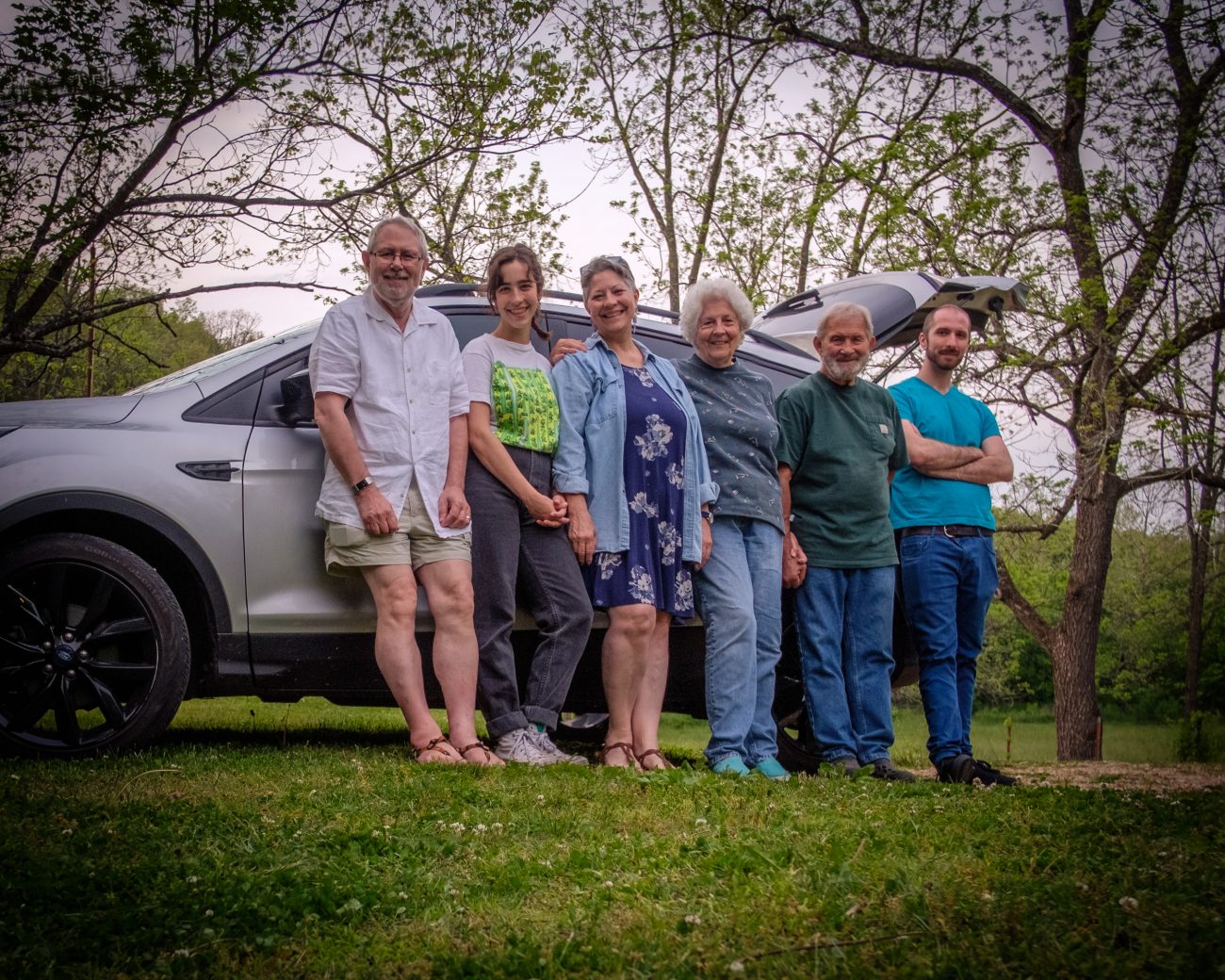
Family Day – Spent with Carol & Jim to celebrate Lanie’s Graduation. Katie was also with us but unfortunately, she left before we decided to take a picture. Katie’s getting ready to head back to Colombia for a visit. Copyright © 2021 Gary Allman, all rights reserved. -
Grammarly writing streak

Maybe it’s about time I had a real vacation with zero writing for more than a week.
-
Birdbath for Ginger


Thursday was a day of gifts. Carol bought me some farm-fresh eggs, and Jim brought us this wonderful sculpture/birdbath.
It took a while for Jim to get it set in the ground straight, but it was worth the effort. Now to see if the birds will use it.
Update – I watched a bird taking a drink from the birdbath an hour or so later.
-
Behind the lens

Behind the lens. Gary Allman, May 8, 2021. Copyright © 2021 Gary Allman, all rights reserved. I borrowed Ginger’s 60mm lens to take pictures of our new birdbath. I’ve not used this lens much, we bought it for its macro capabilities, and it stays on Ginger’s studio camera most of the time. While it was on my camera, I thought I’d grab a quick selfie in the bedroom mirror and try it out.
The more observant among us will notice that I’ve flipped the picture the right way around in Photoshop.
-
Adult and juvenile male Rose-breasted Grosbeak

Adult and juvenile male Rose-breasted Grosbeak — this winter we put up four (yes four), bird feeders in front of the ‘Sparkle Zone’ windows. These new visitors arrived today. Copyright © 2021 Gary Allman, all rights reserved. This winter we put up four (yes, four) bird feeders in front of the ‘Sparkle Zone’ windows.
Along with a fifth feeder on one of the trees, they’ve proved to be very popular with the local birds and squirrels. These new to us visitors, an adult, and juvenile male Rose-breasted Grosbeaks and two females, arrived today.
Taking a picture through two panes of (dirty) glass doesn’t make for tack-sharp pictures, but this will have to do.
-
Breakfast; crispy bacon, eggs, and tomato

Breakfast; crispy bacon, eggs, and tomato – Yesterday Carol gave me two farm-fresh eggs. Copyright © 2021 Gary Allman, all rights reserved. Breakfast; crispy bacon, eggs, and tomato – Yesterday, Carol gave me two farm-fresh eggs. She said she wished she could be there to see my face when I cracked them.
Yes, they really were that deep orange color.
-
Whites Creek Trail completed

Whites Creek Trail completed – now just to hike the short spur trail back to the parking lot. Copyright © 2021 Gary Allman, all rights reserved. Day One
Day Two
Day Three
-
Final crossing of Whites Creek

Whites Creek – has lots of large (very large) pools. I had planned to spend my third night camped near one of them. But I had to cut my trip short for a family dinner. Copyright © 2021 Gary Allman, all rights reserved. -
Fiddler Spring

Fiddler Spring – I took a quick detour to checkout the spring and top up my water. Copyright © 2021 Gary Allman, all rights reserved. After the most impressive Bliss Spring, Fiddler spring was a bit of a let-down. But it was a source of water, and I needed to top mine up to see me through to the end of my hike.

Pack it out – don’t leave your trash behind. Also, make sure your fire is dead out. Despite the rain, the fire was still smoldering. I doused it before I moved on. Copyright © 2021 Gary Allman, all rights reserved. There’s a nearby campsite, that comes ‘equipped’ with crate chairs, a line to hang your hunting kills on, and a large fire ring. Someone had obviously stayed overnight. They’d left trash in the fire, and hadn’t bothered to put the fire out. despite the rain, it was still smoldering. I doused it before I went on my way.
-
Hello li’l buddy

Hello li’l buddy. It’s probably as fast on the trail as I am. Copyright © 2021 Gary Allman, all rights reserved. -
Looking back along Whites Creek Trail

Looking back along Whites Creek Trail Copyright © 2021 Gary Allman, all rights reserved. This is fairly typical of the trail conditions I encountered. Note the (fairly) recently cut deadfalls.
At this point, it started to rain, and it carried on raining for the next four hours.
-
Looking into Whites Creek Cave

Whites Creek Cave. Copyright © 2021 Gary Allman, all rights reserved. No I didn’t go in. I took this picture through the grill using my headlamp at full brightness to light up the cave. Had I been thinking, I would have set the camera on my mini tripod and gone for a longer exposure and some light painting.
There’s nothing to give the picture any feeling of scale. Let’s just say, “Pretty big.”