-
Meet Arty (Artopus)

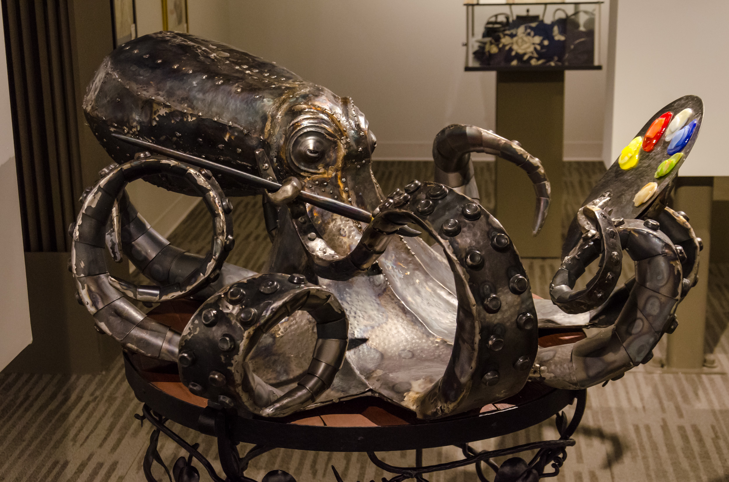
Meet Arty (Artopus) – Sculpture by Jim Davis. Copyright © 2019 Gary Allman, all rights reserved. 
Jim and Artopus. Copyright © 2016 Gary Allman, all rights reserved. Doesn’t everyone have a large, beer swilling, artist-in-residence octopus in their living room?
Arty’s been living with us for quite a while now but this is the first time I’ve stopped to take a picture of him.
Doffing my cap at the artist, I should say that the beer can was an unauthorized addition that I perpetrated. We also think that a large Rastafarian hat might look quite fetching on him.
Update: I found my pictures of Artopus and Jim from when Artopus was on display at the Ozarks Regional Arts Council Exhibition, Mountain Home, Arkansas in 2016.

Artopus by Jim Davis. Copyright © 2016 Gary Allman, all rights reserved. -
Lenten Altar – Church of the Good Shepherd

Lenten Altar. Episcopal Church of the Good Shepherd, Kansas City, Missouri. Copyright © 2019 Gary Allman, all rights reserved. My second (but not my last) Saturday in Kansas City this month. I’m visiting Good Shepherd to attend a deanery meeting and shoot some video. While I was here I picked up a few shots to accompany the diocesan daily prayers.
Fortunately at the meeting I managed to find someone to stand-in for me next weekend and take pictures of the ordinations to the transitional diaconate taking place at the cathedral. I’ll be back in KC on the 30th though.
March has been, and continues to be, busy. Weekends: three one day workshops, and a deanery meeting (three days in Kansas City). Then during regular work hours there’s two newsletters and the magazine to get out. All this on 20 hours a week. Somehow I think not. Each trip to KC requires six hours in the car.
It’s going to be touch-and-go getting my two nights and 20 miles on the trails this month.
-
My desk was looking cluttered this morning

Cluttered Desk – Well it doesn’t look quite as much of a mess in this picture. Copyright © 2019 Gary Allman, all rights reserved. I was out working in Kansas City yesterday. I left home at 6:00 am, and got back around 6:30 pm. On arriving back I dumped out the loose content of my gear bag onto my desk. This morning I was standing musing on the mess when the urge to take a couple of pictures came on.
I was reminded of the saying that the state of one’s desk reflects the state of one’s mind, “A tidy desk equals a tidy mind”. For the last several months, my mind — and my desk — have been in a messy place; I’m not sure what the cause is. A bit of depression, a bit of listlessness, a lack of enthusiasm? Who knows? The mind is a messy and strange thing in and of itself, well mine is.
Anyway, to me the desk looked a mess. I’ve spent years with a ‘clear desk policy’ whether self or corporately imposed, I’ve found it helps. I’ve also told myself the story that what would also help is building a new desk top with drawers and putting up office shelves. I’ve been promising myself those things for a long time. I’d then be able to keep the keyboard and mouse of which ever computer I wasn’t working on out of the way, and all my fountain pens would have a home that wasn’t just laying on the desk top. Well that’s the excuse I want to tell myself for not keeping it clear.

Cluttered Desk – The full deal. Working from farthest right towards the camera, the reality is that my :
- hand bearing compass (an obvious thing that one uses all day every day while standing at a desk),
- driving glasses,
- Capture Pro camera clip,
- cell phone,
- daily pills,
- 35 mm lens,
- lens cap,
- chewing gum,
- empty glass,
- lighter,
- knife and multi-tool,
- mini tripod,
- Cell phone bracket,
and on top of the speaker: - film container full of Allen wrenches.
Just need to be put away. The rest can stay.
-
Peak Design Capture Pro V3

Peak Design Capture Pro V3 – I’ve had this a year now, and it’s one of the most useful pieces of camera gear I’ve bought. Copyright © 2019 Gary Allman, all rights reserved. This morning I was musing on the mess I’d left on my desk when the urge to take some pictures overtook me.
I’ve not had that many spontaneous urges to take a picture in the past few months, so I indulged this one. The subjects were pretty mundane, (this bit of gear, a Peak Design Capture Pro V3, and my desk), but I like the results. I especially like the wear that’s showing on the finish of the Capture Pro, it’s a testament to the amount of use this thing gets.
Exactly what is it? It’s a device that fixes on a belt or strap, and combined with a special base-plate on my camera it allows me to securely (and quickly) fix, my camera to my belt or a strap on my backpack. Removing the camera is just a matter of pushing a button and sliding it off of the clip.
It’s so much better than a camera strap. The camera doesn’t bounce and swing around all over the place like it does on a neck or wrist strap, and it leaves my hands free. It’s great for when I’m hiking and backpacking — the camera is close to hand, but not in the way. Likewise, when I’m working in a church, I can walk around with the camera ready for use, but it’s unobtrusive. That means I can keep the camera with me even up at the altar rail — try doing that unobtrusively with a camera dangling around your neck! In turn that allows me to be in the right place to grab pictures like this …

Fr. Jeff’s first Holy Eucharist as a priest. Copyright © 2018 Gary Allman, all rights reserved. 
Peak Design Capture Pro V3 – In color! 🙂 Copyright © 2019 Gary Allman, all rights reserved. A note about the links. The links marked with a this icon – – are affiliate links, if you buy through them, it doesn’t cost you more, and I get a tiny percentage which helps me offset the cost of keeping this website running. However, please buy from the source that makes the most sense for you!
-
Ready for the First Sunday in Lent

Lenten sanctuary and altar, Grace and Holy Trinity Cathedral, Kansas City, Missouri. Copyright © 2019 Gary Allman, all rights reserved. I took some time out from talking to visit the nave of the cathedral (Grace and Holy Trinity Cathedral). While I was there I grabbed this picture of the sanctuary and altar prepared for the first Sunday in Lent.
-
The End is in Sight

The end is in sight. The tower marks the trailhead and the parking lot. Copyright © 2019 Gary Allman, all rights reserved. Not quite as nice a view as the earlier views to the east and west, but I always like this because the end of the hike (at the tower) is in sight.

Compass Bearing Check – Where I thought I was marked on the map, and where the GPS thought I was. Copyright © 2019 Gary Allman, all rights reserved. I stopped here for some lunch, and to take a compass bearing on the tower and mark off where I reckoned I was on the map. Which I did. I also added a way point on the GPS so I could see roughly how accurate I was.
Not bad. You might notice that my GPS looks remarkably like a cell phone. It is. For $18 I installed an app that lets me use the phone like a GPS. In Airplane Mode the battery consumption is minimal, and following tests I ran over the previous couple of days, at the Devil’s Backbone Wilderness, it performs just as well as my Garmin eTrex. It is also 100% better than the Garmin with the big easy to read screen and simple scrolling and zooming, plus the ‘keyboard’ for typing notes on. It’s a great improvement.
The associated website has facilities to print out the maps and routes you are working with — that’s where my printed map came from. Thus far, I highly recommend it. Gaia GPS.
By 1:20 pm I was back at the trailhead.

The Tower. Copyright © 2019 Gary Allman, all rights reserved. -
I Never Tire Of This View

View from the glades looking northwest. It was quite hot on my hike out. I stopped for a few moments here to enjoy the view.
-
A Quick Diversion Off-Trail

Confluence of Brushy Creek and ‘Cab Creek’. I had hoped that there would be more water running over these stepped falls, but this is what there was.
I was last here in April last year.
-
Back at the Cab

At the Cab – A quick selfie with the cab as I start the final lap of my trip. Copyright © 2019 Gary Allman, all rights reserved. The locals will use just about anything for target practice. I still think this is my favorite picture with the cab.
-
Another Frosty Night

Another Frosty Night – It dropped to 23°F (-5°C). Camped near ‘Cab Creek’. I wasn’t expecting it to get this cold, but it was a good to have some colder nights to try out my new 10° top quilt. It was great by the way.
The amount of frost on the tarp surprised me, and even though it was only a couple of degrees warmer than the previous night, it felt a lot warmer. My water must have felt warmer too, as the bottle I left out didn’t freeze solid.

Lots of Frost – It dropped to 23°F (-5°C) overnight. -
Small Falls on ‘Cab Creek’

Small falls on ‘Cab Creek’. Copyright © 2019 Gary Allman, all rights reserved. Just over an hour after I had started my hike I was at the creek, near to where I planned to spend the night. These falls might be small, but they were making a lot of noise. Not bad for a hand-held picture.
-
About to start part two of my ‘Four Days, Three Nights, Two Wildernesses’ hike

Start of Part Two – Four days, three nights, two wildernesses. Here I am at the registration point at Hercules Glades. Copyright © 2019 Gary Allman, all rights reserved. All signed in and ready to go. One very minor problem, I’ve got no water. I left a bottle of water in the van for this part of the trip, but when I tasted it, it was foul. That was annoying as I’d just ditched some perfectly drinkable filtered North Fork River water. It’s no problem there’s a creek where I plan to stop, and it’s only a couple of miles of fairly easy hiking (I can’t go far as it’ll be getting dark in three hours).
-
One down and one to go

End or Part One – Three nights, two wildernesses. Here I am at the end of my Devil’s Backbone Wilderness trip. Copyright © 2019 Gary Allman, all rights reserved. This isn’t an ordinary trip. I wanted to get a few more miles under my belt, so I came up with the idea for my ‘Four Days, Three Nights, Two Wildernesses‘ hike. Here I am back at the trailhead at the end of the first part: two and a half days, two nights, and one wilderness crossed off the list.
Now to drive a hundred miles, and put in another mile or two before setting up for my third night, this time in Hercules Glades Wilderness. I’m going for something easy. My old favorite, the Pees Hollow Trail.

End or Part One – Before I took my hat off. It was chilly despite the sunshine. What you can’t see. The lower temps caught me out. I’m actually wearing a hiking kilt, which I swapped for the hiking pants I’d left in the van.
I don’t usually meet many people on the trail — especially during the week — today I met eight (according to the sign-in sheet at the trailhead) on horseback. I’ve no idea what they made of me, but one horse was spooked, and one of the guys asked me if there was anything to see. “Just trees and leaves.” I replied. -
A Tad Chilly

Cold Start – It dropped to 21°F (-6°C) overnight, and it was still well below freezing when I hauled myself out of bed. Copyright © 2019 Gary Allman, all rights reserved. I took this picture while I was waiting for the water for a hot drink to warm up.
I don’t have an insulated hood, so I improvised with my shemagh. Very elegant, very old lady. I’m also looking a bit chubby around the chops too. At these temps various bits of gear have to be kept warm — lighter, camera, water filter, battery pack, compass, cell phone. Low temperatures will either freeze them or drain their batteries.
So, I stayed in bed waiting for things to warm up before venturing out. I think I need to add a hood, a better jacket and some insulated hiking pants to my gear if it is going to consistently get this cold while I’m out. 20°F (-6.6°C) is my planned bottom limit out on the trail, though I’ve slept out in the hammock at 16°F (-9°C) while gear testing in the backyard.
In theory, by doubling up some of my gear I can stay warm down to around -20°F (-28°C), but I don’t have the clothes or inclination to test that out. Anyway, who’d want to get out of bed to pee in the middle of the night when it’s that cold?
-
Cold and Frosty Morning

Camped near the North Fork River. The lowest predicted temperature was around 29°F. It actually dropped to 21°F (-6°C) overnight. It was a cold, crispy morning. Everything was covered in frost, including the top and underside of my tarp. One of my water bottles froze solid and the other was very slushy.

Camped near the North Fork River. You can see how the floods have knocked down the trees. 
Frost on my tarp. -
North Fork River

North Fork River from a low bluff. Copyright © 2019 Gary Allman, all rights reserved. The North Fork River was my destination for the day. The place has changed a lot since I was last here. Floods have washed through doing a tremendous amount of damage. I saw the first flood debris about six foot up a tree over 100 yards from the river, so it must have been at least 60′ higher than its present level. where there is low lying ground the banks are choked with downed trees. There were some good campsites near here, but access to the river (for water) was very difficult because of bank erosion, so I headed back to another spot that offered easier access to the river.

North Fork River. The only easy route down to the river was down a sand bank (out of frame to the left). Copyright © 2019 Gary Allman, all rights reserved. I had to climb down a steep sandbank to get some water, but that was a minor inconvenience.

North Fork River. View from the river. Note the pile of trees on the right. Copyright © 2019 Gary Allman, all rights reserved. -
McGarr Ridge Trail – More Ozarks leaves and bare trees.

McGarr Ridge Trail – More Ozarks leaves and bare trees. This sums up hiking in the Ozarks at the moment. Bare trees and fallen leaves.
-
My home from home

Not a soul to be seen – I was several hundred yards from the Mary Hollow Trail (deliberately this time). Copyright © 2019 Gary Allman, all rights reserved. 
Camped off trail – I found a spot well sheltered from the high winds overnight (40 mph gusts). Copyright © 2019 Gary Allman, all rights reserved. I think there are more leaves on the ground here than in the yard, but it could be a close-run thing.
I camped on the western side of the hollow to shelter from the overnight wind which was blowing hard and forecast to be gusting up to 40 mph.
The hammock was set swinging a couple of times, but no trees came down nearby, and I only heard one big limb fall, so my choice of location must have been okay.
By the morning the wind was coming from the north which means it’ll be getting cooler for the next part of my trip.
-
There ought to be a coyote in this picture …

Camped well off the Mary Hollow Trail – The skyline marks the edge of the wilderness at this point. … but I can’t find it.
I was sitting here drinking a nice hot cup of chocolate when some movement in the ravine opposite caught my eye.
I watched a coyote come down the ravine and then proceed to exit stage right along the hollow. With the wind from the north (coming up the hollow from the left), it didn’t catch my scent and had no idea I was there watching it.
By the time I picked up my camera it was almost out of view. I’ve studied the frame for a sign of it, but it must have been holed up behind a tree collecting a stash of Acme TNT when I took the picture. Coyotes are like that. Well, that’s what a little birdie told me.
-
The trails of the Ozarks are starting to look similar

Upper end of Mary Hollow 
Upper end of Mary Hollow – Nice straight trail for a while there, though I was going off-trail to the right to camp for the night. All these trails do have a certain similarity. There’s a nice straight section for a change, though at this point I was going off-trail up the hollow to the right to find some shelter from the wind and camp for the night.