-
Education for Ministry

Education for Ministry – I needed a stock picture to illustrate an article. I couldn’t find one I liked, so I threw this together. Copyright © 2021 Gary Allman, all rights reserved. -
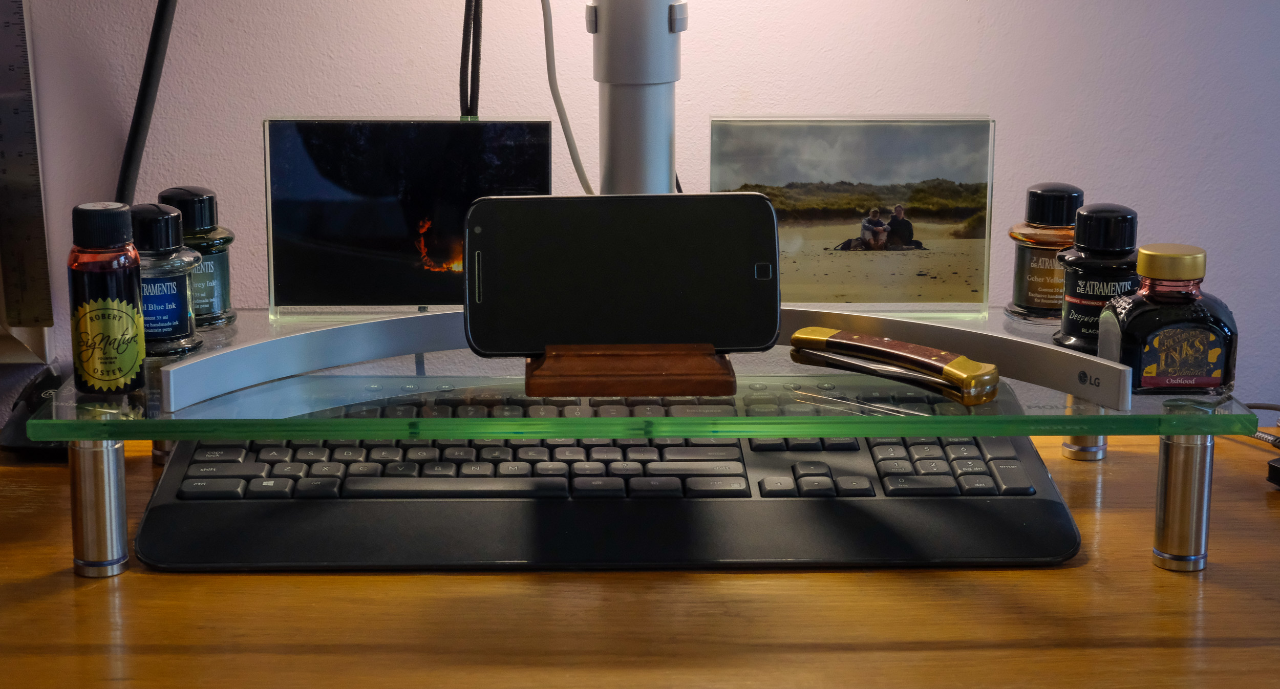
Photographs, inks, cell phone, and Buck 110 knife on my monitor stand

Photographs, inks, cell phone, and Buck 110 knife on my monitor stand – and no I didn’t arrange them for the picture. Me, OCD much? Copyright © 2021 Gary Allman, all rights reserved. -
Weekend cleaning

Weekend cleaning. Copyright © 2021 Gary Allman, all rights reserved. To paraphrase the immortal line from ‘Apocalypse Now,’ I love the smell of gun oil in the morning.
Many years of backpacking have certainly taken their toll on the finish of my Beretta. Especially on the side that’s showing here. That is the side that faces away from my body when it is in its holster. It’s scuffed and scratched from many encounters with pebbly creek beaches and campsite rocks. It’s also spent more hours than I’d like to think about sitting in the rain. It has definitely served as a utilitarian tool rather than some polished collector’s piece stored in a gun safe.
I’ve been meaning to give it a good clean since it spent five hours out in the rain on my Irish Wilderness Trip. Today I finally got around to it and stripped it down, tended to the few rust spots, gave it a jolly good oiling and cleaning, and it’s now all spiffy, ready for its next trip out.
-
Blue Jay

Blue Jay – Pretty, but not popular as they are bossy, noisy, and drive off the other birds. Copyright © 2021 Gary Allman, all rights reserved. This blue Jay happened to arrive as I was sitting on the sofa in the ‘Sparkle Zone’ cup of tea in hand, and my camera within reach.
Taking pictures sitting from the sofa is hardly optimal, even if it is comfortable and cool in the house (it’s been over 103°F – 40°C in the sun today). I was pleased to get a picture at all, even if I had to crop out the window frame. Fortunately, this window is one of the few that doesn’t have a screen.
-
Unused pencil and old plans

Unused pencil and old plans – The plans have been used. They are my notes for a garage storage unit. Copyright © 2021 Gary Allman, all rights reserved. 
Garage Project – Just about done … For now. Copyright © 2019 Gary Allman, all rights reserved. While the pencil remains unused, the plans at least, turned into this.
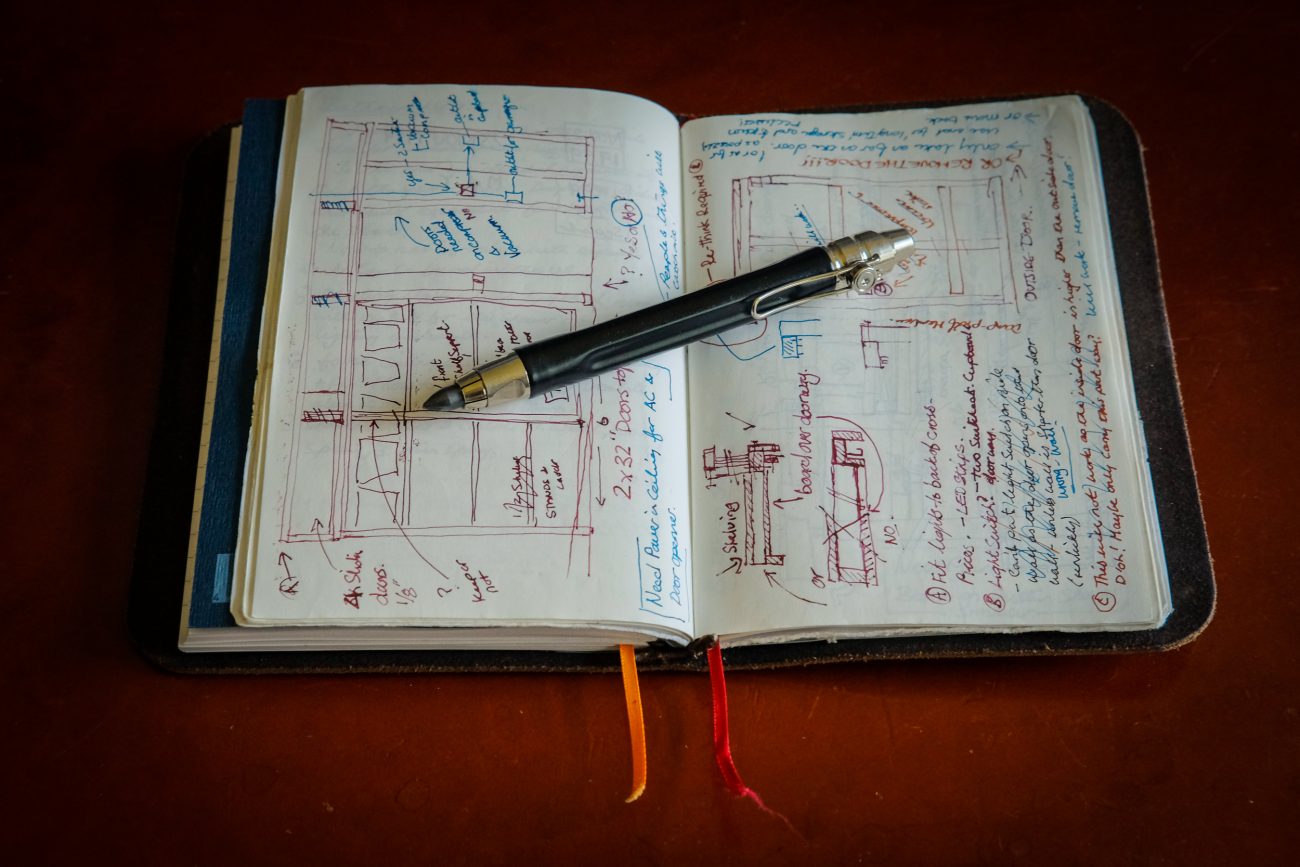
Unused pencil and old plans – The plans have been used. They are my notes for a garage storage unit. Copyright © 2021 Gary Allman, all rights reserved. -
How many journals do you need?

How many journals do you need? I’d say three binders with seven notebooks. That’s what you can see here, and each has a purpose. Copyright © 2021 Gary Allman, all rights reserved. For me, three leather binders holding a total of seven notebooks.
From left to right here’s what I have.
Pocket journal (three notebooks)
This is my carry everywhere; jot down anything journal. The notebooks in this binder are in the slightly smaller, ‘Field Notes’ format, though I use a knock-off brand that reputedly handles fountain pens better. I carry this everywhere, and it fits easily into my pocket. When I’m backpacking, I have a tiny mechanical pencil, and I’ll leave two of the notebooks behind to minimize the overall size and weight of the journal.
Contents:
- Notebook — for jotting odd notes, reminders, etc.
- Outdoors Journal — backpacking and hiking notes, and all my random ‘trail thoughts.’
- Book O’lists — Shopping lists, wish lists, parts lists, any random lists.
Bullet Journal (two notebooks)
work bullet journal — work includes ‘Honey-dos’ and house maintenance too. This is my all-day, everyday, journal. This and my Personal Journal use bigger A6-sized notebooks. I’m a huge fan of the APCA CD10 notebooks.
Contents:
- My Bullet Journal — for a full introduction to bullet journaling, go here: bulletjournal.com.
- Collections — Notes on specific projects, meetings, and reports. You’ll find that collections are described on the bullet journaling website. I keep my collections in a separate notebook because I burn through the bullet journal notebooks quickly, but my collections grow slowly.
Personal Journal (two notebooks)
My late at night, early in the morning journal. You know, where all the whiney, angsty stuff and notes about the weather goes. No? Oh, that must just be me then.
Contents:

Unused pencil and old plans – The plans have been used. They are my notes for a garage storage unit. Copyright © 2021 Gary Allman, all rights reserved. - Personal journal — yada, yada, yawn. I’m no Samual Pepys or Adrian Mole aged 64 ¾.
- Sketchbook — which mainly contains engineering drawings and plans for various construction projects. I probably should keep this notebook in my Work Journal, but I’m convinced that, one day, I will pick up a pencil and start drawing again. I’ve even bought a special pencil just for the job.
The pens
I may as well mention the pens while I’m at it. They are, of course, all fountain pens. The two pens with metallic barrels are Pilot Metropolitans. These are, in my opinion, the best inexpensive fountain pens you can get. I have six altogether. The center pen is a Conklin Duragraph. It doesn’t write quite as well as the Metropolitans, but what a wonderful color and pattern it has. I’ll forgive its slightly scratchy writing experience for the color and looks.
(and inks)

Photographs, ink, cell phone, and Buck 110 knife on my monitor stand – and no I didn’t arrange them for the picture. Me, OCD much? Copyright © 2021 Gary Allman, all rights reserved. Favorite inks — everyday use
- Robert Oster: Red Candy.
- Diamine: Oxblood.
- De’Atramentis: Steel Blue.
- De’Atramentis: Black Brown.
Always on hand…
- De’Atramentis: Sahara Grey (It’s green!).
- De’Atramentis: Ocher Yellow (Orange).
In conclusion
So there you go. Three leather binders and seven notebooks, each with its own purpose in my life. Plus more than you needed to know about my pens and inks. I bet you wish you had never asked.
What? You didn’t ask? Oh well.
Update
For a picture of my current (2023-to-date) journal set up, see this post: Breakfast in America: Journals and Ink.
I now use four leather journal binders and six notebooks, one less than previously; I dropped the ‘Book o’lists.’
- Backpacking journal (one Field Notes style notebook) — a small, lightweight journal which I use only for backpacking and hiking.
- Pocket notebook (one Field Notes sized notebook) — Shopping lists and things I think of while I’m out and about away from my desk.
- Daily journal (two A6 sized notebooks) — my agony aunt, reflections, and my (still) underused sketch book.
- Bullet journal (two A6 sized notebooks) — my Bullet Journal, and its associated collections, for tasks, projects, and their notes.
-
Tree Frog

Tree Frog – it was tiny! Not much over an inch long, laying on one of the wooden boards of the screen on the deck. Copyright © 2021 Gary Allman, all rights reserved. It was tiny! Not much over an inch long, laying on one of the wooden boards of the screen on the deck.
To give an idea of the scale, the vertical distance between the boards is the same as the depth of the boards — I used a board on its side to set the gap when I made the screen.
-
Storm clouds over Ozark

Storm clouds over Ozark – checking on the radar, the storm was nine miles away over Ozark. Note to self — always carry your camera. Copyright © 2021 Gary Allman, all rights reserved. To say it was a huge cloud formation would be an understatement. I had to resort to multiple pictures to get the whole storm.
Taking a picture In the dark on my five-year-old cell phone was never going to have a happy ending, but it turned out better than I expected.
I must remember to carry my camera at all times even on visits to the Riviera1.
1 Riviera. Our name for the parking lot or adjoining parking lot of any fast food joint where we can stop, eat our meal, and watch the world go by. On this occasion, Ginger hadn’t finished work until around nine p.m. and we were headed to a nearby McDonalds’ for a late dinner. We live in style. 🙂
-
View to the southeast from the Pilot Trail, and the hike out

View across Hercules Glades from the Pilot (Tower) Trail. Copyright © 2021 Gary Allman, all rights reserved. We had a nice gentle hike out — albeit uphill most of the way. Going slow suited me as Ginger had requisitioned my hiking poles again. We were all packed up and ready to go by 12:20, the hike started with the bushwhack back to the main trail, after that it was business as usual. We finished our hike shortly after three. There was just one family camping at the trailhead, and apart from the six people on horseback we encountered on our hike in, we didn’t see anyone during our visit. As you can guess, that suits us fine.
There are no end of hike pictures because it rained hard for twenty of our final thirty minutes hiking. We each had a change of clothes in the car, so we didn’t bother with waterproofs and were soaked to the skin. In the 80°F temperatures it was quite nice to be cooled down a bit.
-
Fire ring and campsite

Fire ring and campsite – someone is making themselves at home. Copyright © 2021 Gary Allman, all rights reserved. I showed Ginger a little scenic overlook on a hidden trail (no pictures). It looks like someone has been making themselves a nice little home from home here, just off the short trail leading to the overlook. There was lots of firewood stacked neatly, and the fire ring had been used recently.
-
Journal: Gary & Ginger, a couple of nights at Hercules Glades, June 2021

Gary and Ginger at the Pole Hollow Cairn. Copyright © 2021 Gary Allman, all rights reserved. I know how to treat Ginger to a good time, 🙂 I made sure she had plenty of exercise, time to relax, and her own room with a forest view.
-
Ginger disappearing around a corner on the Pilot (Tower) Trail

Ginger on the trail. Copyright © 2021 Gary Allman, all rights reserved. -
Small spring and creek near ‘Ant Hill’

Small Creek near ‘Ant Hill.’ Copyright © 2021 Gary Allman, all rights reserved. The spring we found can be seen right at the bottom of the frame. The water was pouring out of a small one to one-and-a-half-inch hole in the bank. How well the spring holds up in dry weather will have to be seen.
Looking down the ravine, I saw evidence of how intrusive ‘first world’ trash can be. There was a highly reflective helium balloon caught in the scrub. You can’t see it in the pictures because I ensured it wasn’t in the shot.

Spring – The water was rushing out of a tiny 1″-1.5″ hole (center frame where the weed is collecting). It was putting out several gallons per minute. Copyright © 2021 Gary Allman, all rights reserved.  Spring pool. Copyright © 2021 Gary Allman, all rights reserved.
 Small Creek near ‘Ant Hill.’ Copyright © 2021 Gary Allman, all rights reserved.
 -
Sunday Morning at ‘Ant Hill’

Camped on ‘Ant Hill’ – So named (by us) because of the huge numbers of carpenter ants. We couldn’t decide if the ants killed the trees or they moved in because the trees died. Copyright © 2021 Gary Allman, all rights reserved. We put most of our gear away after breakfast, leaving the tarp up in case it rained — it did, but only a few sprinkles. We sat around chatting and looking at the trees until noon, when we packed away the last of our gear and headed back to the trailhead.
No pictures of us because we were slopping around in comfortable clothes, and I couldn’t be bothered.
 Camped on ‘Ant Hill’ – So named (by us) because of the huge numbers of carpenter ants here. We couldn’t decide if the ants killed the trees, or they moved in because the trees died. Copyright © 2021 Gary Allman, all rights reserved.
 Camped on ‘Ant Hill’ – So named (by us) because of the huge numbers of carpenter ants here. We couldn’t decide if the ants killed the trees, or they moved in because the trees died. Copyright © 2021 Gary Allman, all rights reserved.
 Camped on ‘Ant Hill’ – So named (by us) because of the huge numbers of carpenter ants here. We couldn’t decide if the ants killed the trees, or they moved in because the trees died. Copyright © 2021 Gary Allman, all rights reserved.
 -
Saturday evening, camped on ‘Ant Hill’

Camped on ‘Ant Hill’ Copyright © 2021 Gary Allman, all rights reserved. We called this place ‘Ant Hill’ because of the huge number of carpenter ants. We couldn’t decide if the ants killed the trees or they moved in because the trees died.
We had a very relaxing day with nothing much done except sitting around talking and enjoying the woods and sunshine. When the forecast rain arrived, it was just a very light sprinkle, but that was enough for us to shift our seats under my tarp, which I had already set up in porch mode just in case it rained.
Arriving yesterday evening, we had first tried to set up camp in one of my usual sites on the edge of ‘Twin Falls Hollow,’ but the ground wasn’t flat enough. Some searching around found this spot a couple of hundred yards west. We were lucky and found a small spring nearby, so we didn’t need to slog all the way down the hill and back up again to get water.
-
Ginger’s new tent

Ginger’s new tent – we splurged a lot of cash on an ultralight (20oz) DCF tent. Now Ginger or the kids can come out with me. Copyright © 2021 Gary Allman, all rights reserved. We have been very pleased with the Zpacks products we’ve bought to date (Arc Haul Backpack, trekking poles, and various DCF bags), so when Ginger started looking at tents, Zpacks was high on our list. Our decision to purchase a Zpacks Duplex tent was also helped by the many positive reviews we found online.
In use we’ve had no problems. It’s simple and quick to setup and breakdown. We have also bought the Duplex Freestanding Flex kit for hard surfaces when we are car camping.

Ginger’s new tent – we splurged a lot of cash on an ultralight (20oz) DCF tent. Now Ginger or the kids can come out with me. Copyright © 2021 Gary Allman, all rights reserved. Updates
- May 2025 — I realized I hadn’t said what tent we’d bought! I’ve added some text about it based on our experience with it over the past four years.
-
Flowering Prickly Pear Cactus

Flowering Prickly Pear Cactus. Copyright © 2021 Gary Allman, all rights reserved. 
Flowering Prickly Pear Cactus. Copyright © 2021 Gary Allman, all rights reserved. -
Gary and Ginger at the Pole Hollow Cairn

Gary and Ginger at the Pole Hollow Cairn – I know how to treat Ginger to a good time, I made sure she had plenty of exercise, time to relax, and her own room with a forest view. Copyright © 2021 Gary Allman, all rights reserved. -
Gary and Ginger at the Pole Hollow Cairn
Gary and Ginger at the Pole Hollow Cairn. Copyright © 2021 Gary Allman, all rights reserved. I know how to treat Ginger to a good time, 🙂 I made sure she had plenty of exercise, time to relax, and her own room with a forest view.
Gary and Ginger at the Pole Hollow Cairn. Copyright © 2021 Gary Allman, all rights reserved. I couldn’t resist the opportunity to show Ginger her rock on the Pole Hollow Cairn, and of course, there’s the Pole Hollow selfie that must be taken. Ginger is never one to miss the chance to ham things up, and there are several outtakes.
It’s been a long time since we last went backpacking together, just over three years. In that time the fabric in our now ten-plus-year-old tents has started to degrade and get sticky. I did a lot of research seeking a replacement that would work as a single or two-person tent, and one that hopefully would last a lot longer than our deteriorating MSR Mutha Hubba and Sierra Designs Lightning XT 1 tents have.
The girls have indicated that they’d like to come out backpacking with me, and Ginger wants to get out more. The time was right, and we bought an ultralight Zpacks Duplex tent that weighs in at a minuscule 24oz. Much lighter than my hammock set-up. I might have to try ground-dwelling again.
Our plan for the weekend is very simple. Hike in around three-and-a-half miles, set up camp, do nothing for a day and a half, and then hike back out. The weather should be good, 80°F daytime temps and 66°F nighttime. There’s some rain forecast for Saturday night and Sunday. No problem, and I’m certainly no stranger to hiking out in the rain.
The only problem I had on the hike in, was lending Ginger my pair of carbon fiber trekking poles to try out. I never got them back!
-
Back to the start and some notes

Mystery Trail. The trail I arrived on is coming in from the right, but the blazes suggest there’s another trail. It’s a puzzle, and there was no visible trail. Copyright © 2021 Gary Allman, all rights reserved. From here there is just a short thirty-minute hike, south, down the Ozark Trail to get back to the trailhead. That’s it, trip over, though there’s still the two-hour drive home to complete. The placing of the trail blaze here is a puzzle. I came in on the trial from the right, and the main trail is off to the left, so what is that trail blaze doing center frame? At first, I thought it was just badly placed, but looking more closely at the picture I can see another blaze on a tree in the direction it is pointing. I didn’t notice a worn trail joining here from that direction.
Well, this interesting question, the fact that I missed out on the top northwest corner of the North Fork Loop, and that I’d like to come back when the trees are not in leaf, all mean a return trip is needed. There is also the issue of the missing link trail to the Devil’s Backbone Wilderness to be investigated.
In total I hiked a meager 12.54 miles with 1,400 feet of elevation. Not a big hike at all. I’ve almost done that mileage in a day!
Lessons
- Thoroughly check new gear before leaving. If I had I wouldn’t have ended up with no way to charge my electronics.
- Remember to download the maps to my phone before leaving.
- Check where I am heading with the compass and map — especially if I am not using the GPS. I know this, I don’t know why I don’t do it. I’ve even changed where I keep the compass and map to try and remind me.
- 2H pencil leads are unreadable. Change back to HB.
- Trails move and they may also be closed. Check my route.
- I can make a gallon of water last a night and most of the next day.
- I took more clothes than I needed. I had my medium fleece that I never wore, I could have carried my light fleece.
- Don’t take the underquilt protector when the forecast doesn’t call for it.
What worked well
- While it didn’t get a proper test the new battery pack seemed to work fine. It powered the lights without shutting down, which is a problem with my old battery pack.
- My food and water planning were good.
- And while I lost the trail (a lot) I got around and visited all (okay most) of the places I planned on visiting.