-
Katie’s last high school orchestra concert

Katie’s last high school orchestra concert Jim, Carol, Lanie and Emilie joined us to watch Katie’s final high school concert.


-
Bluffs on Harry S Truman Reservoir

Bluffs on Harry S Truman Reservoir This was the last bit of the shore we examined before heading back to the campground.
You can read a full write up of our weekend and see a lot more pictures in our post on Ozarks Walkabout.
-
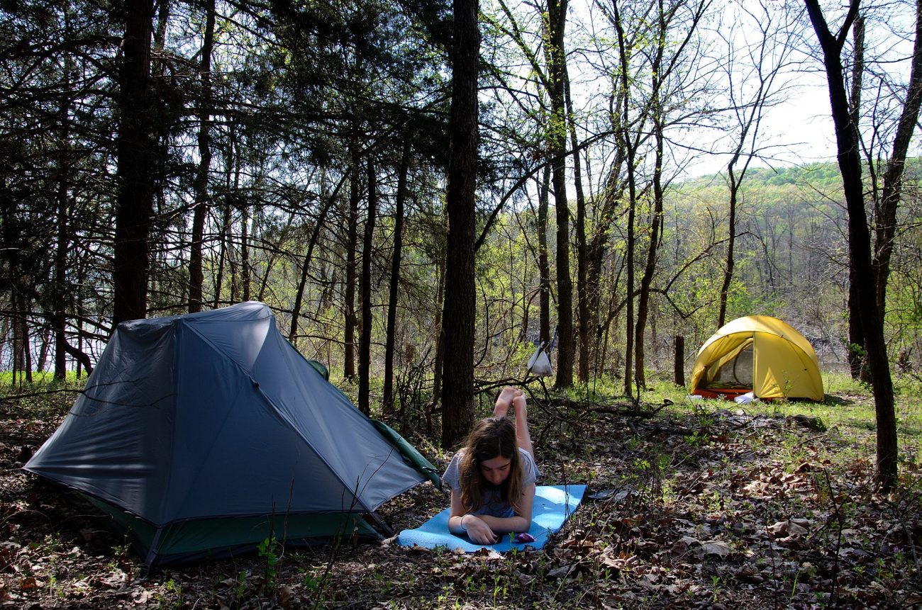
Ascend D10 & Ascend FS10 Kayaks at Berry Bend, Harry S Truman Reservoir

Our Ascend D10 & Ascend FS10 Kayaks at Berry Bend, Truman Lake. Copyright © 2012 Gary Allman, all rights reserved. The dew and the quality of the light caught my eye.
Read our comparison of the 2012 Ascend FS10 and Ascend D10 Kayaks, and our article on fitting out my Ascend FS10 Kayak.
-
Early Morning mist on the lake – Berry Bend, Harry S Truman Reservoir

Early Morning mist on the lake – Berry Bend, Truman lake, Missouri
This was our view of Truman lake first thing Saturday morning. Wonderful. Ginger got a better picture of this, but I’m quite happy with this image.As we had to be in Kansas City Sunday to pick up a group of youth group kids, we decided to drive up to Berry Bend Friday afternoon and camp Friday and Saturday. The campground is 100 miles nearer to Kansas City, so we could get away without an early start Sunday. Our plan: to get some R&R and time in our kayaks out on the lake.
You can read a full write up of our weekend and see a lot more pictures in our post on Ozarks Walkabout.
-
Choices: Hiking the Silver Trail at Busiek State Forest and Wildlife Area

Choices: Hiking the Silver Trail at Busiek State Forest and Wildlife Area. Copyright © 2012 Gary Allman, all rights reserved. The Silver trail loops here – whichever way you go you’re going to end up climbing and descending the 300′ hill in the distance. We’ve never done this loop clockwise so today we decided to give it a try. Whichever way you go the slope is steep in places between almost 1:2 and 1:3.


-
Rest stop – Piney Creek Wilderness

Rest stop – Piney Creek Wilderness We took a picture of us resting here on January 1, 2012, so we had to stop and take another picture, this time with Lanie.
You can read about our trip here: Ozarks Walkabout.


-
Record temperatures meant a wallow in Piney Creek was necessary

Record temperatures meant a wallow in Piney Creek was necessary It was hot and record temperatures were predicted. So, after filtering enough water to last us our hike back to the trailhead I decided that I’d lie in the creek a while and get soaked before we started climbing the 600+ feet out of the wilderness.
Lanie decided that she’d do the same. It was quite refreshing, and in the heat we dried off very quickly.
You can read about our trip here: Ozarks Walkabout.

Record temperatures meant a wallow in Piney Creek was necessary -
Table Rock Lake at Piney Creek Wilderness

Table Rock Lake at Piney Creek Wilderness We took Lanie on her first backpacking trip. You can read about it on our Ozarks Walkabout Website.


-
Tenacious

Tenacious – Johnson’s Shut-ins State Park Johnson’s Shut-ins are a hugely popular natural water park. We were fortunate to have the place to ourselves. We spent our time climbing around on the rocks – the water was far too cold to try out. I spotted this dandelion and it reminded me of a picture I took of my son Robert while on vacation in Scotland over twenty years ago.
-
Journal: two nights at Bell Mountain Wilderness, March 2012

The geology on this side of Missouri is very different to the Limestone Karst Geology we are used to Eager to find a new sort of ground to cover, we turned our attention to the St. Francois Mountain area for our Spring Break trip. The St. Francois Mountains are an ancient granite mountain range that stands, literally, as an island in the limestone and dolomite former sea beds that are the Ozarks Plateau. Instead of the usual tan and white Ozarks rocks, this region is strewn with boulders and rocks of maroon rhyolite and pink granite. These hard igneous rocks were formed in a completely different manner, and weather differently to the sedimentary rocks found elsewhere giving rise to much different scenery than the rest of the Ozarks.
Day 1, Getting to Bell Mountain Wilderness
The children typically spend Spring Break with their father so that means we need to get them to the train station in St. Louis and then pick them back up a week later. With the price of gas being what it is and with the itch for the outdoors being what it is, we like to turn Spring Break into a backpacking trip. Last year we hiked the Berryman Trail.

The Northern Trailhead parking lot is just a wide spot in the road. The original plan was to car camp at Meramec State Park the first night so we could take our time in St. Louis (REI was calling) and not have to pitch the tent in the dark. But the forecast for later in the week was looking grim with lots of rain expected and we didn’t want to waste half of our second day driving. So we opted to head straight to Bell Mountain Wilderness in Iron County, and camp at the trailhead. We had no idea if there would be a campsite there, but Wildernesses, in our experience, typically do. As we left St. Louis the rain began and it rained heavily until we were quite near Potosi. Then suddenly the clouds parted, the temperature went up 15 degrees, and the ground was dry.
It was a pretty drive with the late afternoon sun lighting up the newly green pastures. We found the north trailhead of Bell Mountain Wilderness without incident. The gravel road to the trailhead was well maintained and easy going. However, there was only a small parking area and no place to camp. We had another hour until sundown so we decided to load up the packs with two days’ supplies and head out onto the trail. We figured we’d find a flat spot soon enough and set up camp for the night. The only problem was there was a storm brewing overhead complete with lightning, and we were on a ridge. I did not like this. We hiked pretty darned fast southward on the trail, hoping at we’d find a site to pitch the tent.
We didn’t get rained on and we didn’t find a site until nearly three miles in when we started down the main loop in the center of the Wilderness. It wasn’t perfect but it was good enough. We pitched the tent by the light of our headlamps and had a lovely dinner. As usual we slept like logs. It always feels so good to get out in our tents after we’ve not camped for a while. (“A while” being three weeks as our last trip was to Truman Reservoir in February.)
Day 2 Bell Mountain Wilderness
The day started warm and breaking camp worked up a sweat. In all our wandering around in the dark trying to find a flat spot for the tent the night before, we had inadvertently finished up a bit closer to the trail than we typically like. As I was taking down the tent we saw hikers going down the trail which was a mere 50 feet away. Oops.

Ginger getting breakfast ready sitting in our Mutha Hubba tent. Bell Mountain Trail, Missouri 
2010 MSR Mutha Hubba tent in Ozarks woodland on a ridge in the Bell Mountain Wilderness. 
2010 MSR Mutha Hubba tent in Ozarks woodland on a ridge in the Bell Mountain Wilderness. We continued down the hill and for some reason my feet were killing me. I staggered and stumbled as the trail descended into Joe’s Creek. It was a wide, forested creek drainage and that meant lots of wildflowers that I had to stop to take pictures of. Just before the trail rounded a corner and went up another creek, we found an area that looked to be a former homestead. Others have obviously found this area to be nice as there were two fire rings where people pitch camps.
Before we left the creek, we stopped to fill up with water. Then we started the 400 ft climb to the ridge of Bell Mountain itself. As we’d done little hiking or backpacking over the last couple months, we were sorely out of shape and really felt the climb. We had to stop every 50 feet and catch our breath. The view was incredible, though. I do love hiking in the hills when there are no leaves on the trees. We could also see the substantial damage to the trees from the 2010 Derecho wind event. The trails are clear, though, and it gave tired old me lots of good logs to rest on as we went up the hill.
Near the top of the ridge we found our first exposure to the granite boulders that the St. Francois mountains are known for. I was surprised to find them to be a dark maroon color, not at all like the gray granite I was expecting. The rocks, however, appear gray because they’re covered with lichens of all sorts.

Granite Boulders – Bell Mountain Wilderness The geology on this side of Missouri is very different to the Limestone Karst Geology we are used to Once on the ridge, the trail became smooth and flat and easy. We saw evidence of recent horse traffic but the trails didn’t show as much horse wear and tear as we’re used to in southern Missouri. The view on either side of the ridge was great. Soon we began the last climb to the top of Bell Mountain at 1702 feet. There was a large and bare fire ring and campsite at the summit but it looked a bit too dirty for my taste. We checked with the weather radio for the forecast and decided to carry on and go down the mountain.
 Gary near the summit of Bell Mountain in Iron County, Missouri. It’s a drop-off of 700 feet down to the valley below where Shut-In creek runs.
 Glades near the summit of Bell Mountain
 A survey marker at the summit of Bell Mountain Wilderness. Oddly, this was the second marker that I found, this one seemed to be a few feet higher than the other one.
 At the summit of Bell Mountain in Iron County, Missouri, we found this survey marker. It was hard to read. I think someone took the warning about defacing it as a challenge. Copyright © 2012 Ginger Allman – www.ozarkswalkabout.com
 Near the summit of Bell Mountain in Iron County, Missouri, Gary looks over the valley which holds Shut-In Creek. Copyright © 2012 Ginger Allman – www.ozarkswalkabout.com
 Gary was listening to the weather radio while sitting next to a fire ring at the summit of Bell Mountain (1702 feet).
Before that, though, we checked out the igneous glades to the east of the summit and the incredible, incredible view. Gary was surprised to see how big the Taum Sauk Reservoir is. We could hear voices and children and found that a couple of families had camped just north of the summit. They had just returned from a bushwhack down the 700 ft mountainside to Shut-In Creek below. On the way back they’d seen a big rattlesnake with 11 segments on its rattle.
We continued down the hill, marveling at the 25 foot boulders strewn on the hill. The trees were short and stunted, the bark was gray, the boulders were gray, it had a surreal and otherworldly feel. Gary asked me, jokingly, if I had the change in scenery that I had been seeking. I had. It was wonderful. At some point going down the hill, though, I got myself turned around (which never happens) and was convinced we were going in a direction that the sun, the map, and the GPS all told me was incorrect. Oh well. I accepted that I sometimes make mistakes. But even now, that part of the trail feels turned around in my head. I guess this just goes to show you that you must always hike with a map and a compass, even if you’re experienced, because you can get mentally turned around.
We could see on the topo map that there was a good flat area to camp ahead so we headed there. We had a nice evening sitting in our chairs on the flat rocks of a glade. I was shocked to see evidence of a campfire on these rocks. You should never, ever camp on a glade as it’s a fragile environment that doesn’t recover quickly from human damage. We saw some wild turkeys and heard some owls. And just as the sun was setting I could see a bright light in the western sky. I assumed it was sunlight reflecting on an airplane. No, it was Venus. And the sun was not yet down. How odd.
Day 3 Hiking out of the wilderness and where to go next?
 We had hoped to camp at the top of Bell Mountain, there is a campsite there but it is very close to the trail, heavily used and rather gross, so we carried on.
 View from the tent – Bell Mountain Wilderness
We woke to another perfect and unseasonably warm sunny day. The trip back to the trailhead was uneventful. The trail surface is very easy going throughout this wilderness with none of the large rocks and difficult footing that we often see in the western part of the Ozarks. On the way out we passed what appeared to be a very old pile of trash. Later we checked the cans online and reckon they are from the seventies, which shows how long discarded trash can stay in the environment. The simple lesson is -Pack it out.
 Checking the cans, we think this trash is from the seventies – which just goes to show how long trash that’s left in the wilderness will remain.
 Bell Mountain Trail Fork
 Bell Mountain Trail
 Typical trail conditions – Bell Mountain Trail
 Sure enough, when you have a nice dirt trail and it rains, you\’ll have a nice muddy trail. Nobody likes to get all muddy, but it\’s much healthier for the woods if you walk in the middle of the path. Walking on the edges tramples vegetation and leads to the trail getting wider. BTW, now you see one huge advantage for shoes like Gary\’s hiking huaraches. If his feet get muddy he just washes them off at the next creek crossing. Copyright © 2012 Ginger Allman – www.ozarkswalkabout.com
We were out of water and thinking of how good a swim in a creek would feel. The map told me that the western trailhead of Bell Mountain Wilderness was near a creek. And sure enough, it was. So we sneaked off down behind the bushes to the creek and dove in. Nothing feels quite so good as a clean body after a backpacking trip. Even if the water was (insert expletives) freezing. By the way, we never use soap in waterways. Soap has an adverse effect on fish’s gills and the environment in general. We rinsed our clothes in the water and hung them up to dry. We backpack with quick-drying nylon clothes, so this only took a few minutes while we ate our lunch in the parking lot at the trailhead.

The trail here starts with a six hundred foot climb to the ridge – which is why we decided to use the trailhead on the other side of the Wilderness – it is on the ridge saving a lot of climbing. 
Once we’d finished hiking back to the car we drove to the other trailhead to check it out. We had a very cold but welcome bath in the near-by Ottery creek. The weather story underlying all our decisions on this trip was a cut-off low pressure system sitting over Kansas and western Missouri. Each day the forecast would call for the system to come eastward and put an end to our good weather with heavy rains. While we don’t mind camping in the rain, we don’t want to be in a situation where we’re behind creeks in heavy rain. At first we expected we’d stay at Johnson’s Shut-Ins State Park for a couple of nights but now we found the forecast had put off the storm system another day and we could still make another day backpacking. But where? The day was getting late. We wanted to get somewhere and get camp set up before it was dark. We’re too old and too unsteady to relish climbing over granite boulders in the dark. Some things are just dumb.
We had a few limited maps I’d printed off and a couple of jpegs saved on our netbook but really no idea about what the area held except for the Wildernesses and State Parks. Signs for camping almost always mean commercial RV sites. We threw caution to the wind and drove 50 miles to Rock Pile Mountain Wilderness. We do like our wildernesses, and that’s a story for another day.
-
Sunset over Estillyen – Oil on canvas

Sunset over Estillyen – Oil on canvas You would think that photographing a painting or prints is a nice simple job. Unfortunately, it’s a highly specialized area, requiring skill, patience, and special equipment to ensure there are no unwanted reflections or highlights. The lighting has to be perfectly even, but at the same time, it needs to show the texture of the paint. There’s also a lot of effort involved in ensuring the colors are faithful to the original artwork.
I was commissioned to photograph this oil painting for the cover of the book ‘Messages from Estillyen.’
-
Katie – pictures rescued from the cutting room floor

Katie. Copyright © 2012 Gary Allman, all rights reserved. This is one way to embarrass your (step) children.
I found these pictures in 2015 and thought they’d be worth processing and sharing.
 Katie. Copyright © 2012 Gary Allman, all rights reserved.
 Kate and Lanie obviously have something in common. Copyright © 2012 Gary Allman, all rights reserved.
 Katie. Copyright © 2012 Gary Allman, all rights reserved.
 -
Lanie (January 2012)

Lanie. Copyright © 2012 Gary Allman, all rights reserved. October 2013.
I recently had a problem with my photo libraries, which meant I got to sit and watch while the software re-built the database of over 30,000 pictures. While it does this it momentarily flashes up a tiny copy of each picture. staring aimlessly at the screen I spotted this group of pictures I took in January 2012 and never got round to processing. Well, now I’ve processed them…

Happy Lanie.Copyright © 2012 Gary Allman, all rights reserved. 
Complete with smiley marker pen on her arms. Lanie. Copyright © 2012 Gary Allman, all rights reserved.  Typical Lanie… Copyright © 2012 Gary Allman, all rights reserved.
 Getting ready to be a Teenager… Copyright © 2012 Gary Allman, all rights reserved.
 Getting ready to be a Teenager… Copyright © 2012 Gary Allman, all rights reserved.
 Happy Lanie.Copyright © 2012 Gary Allman, all rights reserved.
 Lanie. Copyright © 2012 Gary Allman, all rights reserved.
 Lanie. Copyright © 2012 Gary Allman, all rights reserved.
 -
Katie and Lanie

Katie and Lanie January 28, 2012. Copyright © 2012 Gary Allman, all rights reserved. 
Katie & Lanie. Copyright © 2012 Gary Allman, all rights reserved. 
Katie and Lanie January 28, 2012. Copyright © 2012 Gary Allman, all rights reserved. -
Lanie – pictures rescued from the cutting room floor

Lanie – 2012. Copyright © 2012 Gary Allman, all rights reserved. As it was Lanie’s birthday this week I couldn’t let her escape my sweeping up of old lost pictures. Here’s a link to some more pictures from the same session.

Lanie 2012. Copyright © 2012 Gary Allman, all rights reserved. -
Lanie

Lanie in her Bishop’s Ball Finery. Copyright © 2012 Gary Allman, all rights reserved. -
Katie

Katie in her Bishop’s Ball finery. Copyright © 2012 Gary Allman, all rights reserved. -
Gary

Gary – January 28, 2012. Copyright © 2012 Gary Allman, all rights reserved. Katie and Lanie were dressed to the nines to go to the Bishop’s Ball.
We decided to set up the garage studio and take some pictures. While we had the lights and backdrop set up for Katie and Lanie I thought I’d sneak in a quick self-portrait. I can’t remember if this was a lighting test shot or one I took after we’d finished with the girls.
 Katie and Lanie January 28, 2012. Copyright © 2012 Gary Allman, all rights reserved.
 Katie & Lanie. Copyright © 2012 Gary Allman, all rights reserved.
 Katie and Lanie January 28, 2012. Copyright © 2012 Gary Allman, all rights reserved.
 Katie in her Bishop’s Ball finery. Copyright © 2012 Gary Allman, all rights reserved.
 Lanie in her Bishop’s Ball Finery. Copyright © 2012 Gary Allman, all rights reserved.
 -
Woods Fork – Busiek State Forest and Wildlife Area

Woods Fork – Busiek State Forest and Wildlife Area A 6.6 mile hike with 800′ of elevation climbed on Busiek’s White and Orange Trails.
-
Gary and Ginger stop for a drink and snack on the way back to the Tower Trailhead – Piney Creek Wilderness

Gary and Ginger stop for a drink and snack on the way back to the Tower trailhead. Copyright © 2012 Gary Allman, all rights reserved. It’s a self-portrait – so shoot me; I like it. We were on the last lap of a three-day backpacking trip into the Piney Creek Wilderness. We came back and took another picture here in April.
The end of our backpacking trip
Overnight the wind shifted enabling it to blow down the valley and several trees came down – though none near us, we’d checked the trees near our tent quite carefully, and moved the tent earlier in the day because we didn’t like the look of one nearby tree. In the morning we had a leisurely start to the new year, and took a gamble on a trail that isn’t marked on the map to hike out – Our guess as to where the trail came out turned out to be correct, and we had a fairly easy hike of two and a half miles with a 730 foot climb back to the van, where we celebrated with a new year / end of hike beer.

Gary and Ginger enjoy an end of hike beer. Copyright © 2012 Gary Allman, all rights reserved.